
Search Results


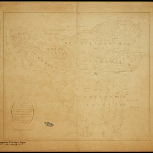
Overzichtskaart van de Residentie Besoeki
1899
Indonesia
This map of the residency of Besoeki (Banyuwangi Regency, East Java) is divided into regencies and districts. Heights of mountains and settlements are given in metres, and distances are shown along roads. Sugar factories and fishing ponds are marked.
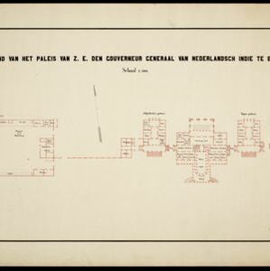
Plattegrond van het paleis van Z.E. den gouverneur generaal van Nederlandsch Indië te Buitenzorg
1899
Indonesia
Floor plan of the palace of the Governor-General of the Dutch East Indies at Buitenzorg (Bogor, Java), now known as Bogor Palace. Although most official business was conducted in Batavia, Bogor was often preferred for its milder climate.

Caart eeniger ryken gelegen op het eyland Groot Java bestaande in het Koningryk Jaccatra de regentschappen Tjanjoer, Bandong, Timbanganten en Batoelejan als mede een gedeelte van Parrakkanmoentjang en Crawang
1898
Indonesia
A hand-drawn late 19th century map of western Java, divided into regencies. The map is orientated with south at the top so that Batavia, on the northern coast of Java, is at the bottom of the map.

Copie no. 2: Plan van den stadt en het casteel van Batavia met een gedeeltevan deszelfs voorsteeden en verdere buijtenplaatse ao 1762
1898
Indonesia
A hand-drawn and coloured plan of the important port city of Batavia (Jakarta), with a detailed legend identifying parts of the city, castle and suburbs. Handwritten notes around the border give the names of roads. Copied from a 1764 map.

Kaart der hoofdplaats Batavia omstreeks het jaar 1740
1898
Indonesia
A mid-18th century map of the important port of Batavia (Jakarta), with military forts, a pier, hospitals, churches, and residential streets. However, the city is also surrounded by fields and plantations, for producing crops and grazing animals.

Kaart van Batavia omstreeks 240 jaren geleden overgebracht in 1864
1898
Indonesia
Although published in the 19th century, this is a copy of a much earlier map of Batavia (Jakarta) from c.1625. It focuses on the castle and fortifications, but also shows the fields of crops and wetlands surrounding the city.


Kaart van het kasteel en de stad Batavia in het jaar 1667
1898
Indonesia
Very detailed map of the port city of Batavia (Jakarta), with numerous locations listed in the multiple legends. The city’s coat of arms—featuring a sword and laurel wreath—and the Dutch East India Company monogram logo—letters ‘VOC’—are also shown.

Noordkust Java: Westervaarwater van Soerabaja
1898
Indonesia
This map of the Madura Strait between Java and Madura is designed to aid navigation: bathymetry (water depth), lighthouses, shoals and reefs, rocks and mud, anchor points, and landmark mountains are all marked. Text describes the tidal conditions.
- Indonesia463
- Malaysia288
- Singapore283
- Brunei277
- East Timor265
- Philippines253
- Thailand240
- Cambodia236
- Vietnam235
- Southeast Asia225
- Laos222
- Myanmar222
- more Simple Location »
- [remove]Java463
- Sumatra311
- Borneo298
- Sulawesi256
- Malay Peninsula249
- Celebes214
- Western New Guinea186
- Maluku Islands183
- Dutch East Indies174
- Siam133
- Sunda Islands133
- South China Sea112
- more Detailed Location »


