
Search Results
Filter
Detailed Location
Java Sea
Remove constraint Detailed Location: Java Sea
Detailed Location
Sumatra
Remove constraint Detailed Location: Sumatra
Place of Publication
Amsterdam
Remove constraint Place of Publication: Amsterdam
Collections
National Library Board Singapore
Remove constraint Collections: National Library Board Singapore
2 Results found

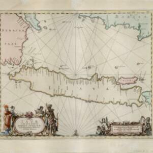
Insulæ Iavæ cum parte insularum Borneo Sumatræ, et circumjacentium insularum novissima delineatio
c.1657-1680
Indonesia
A map of the Java Sea between Java, Sumatra and Borneo. The web of lines is a rhumbline network, used to aid navigation. The cartouche and scale are decorated with paintings of Asian people and mythical creatures including cherubs.


