Search

Search Results

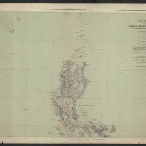
Carta general (en dos hojas) del Archipiélago Filipino

event1900

location_onPhilippines

A Spanish military map of the northern Philippine island of Luzon, highlighting cable and telegraph lines, and aids to maritime navigation such as bathymetry (sea depth) and tide data. A conversion table for metres, fathoms and feet is also shown.

Military map of the Isle of Luzon

event1900

location_onPhilippines

A map of Luzon, Philippines divided into military and civilian regions. Made for the American military, it features roads, railways, telegraph lines, mountains and rivers. An inset map of Manila shows military, civil and religious buildings.

Military district no. 1: Department of northern Luzon

event1900

location_onPhilippines

A map of the northwest coastal region of Luzon, Philippines made for the American military during the Philippine–American War (1899–1902). The area is divided into provinces, and major roads, settlements, mountains and rivers are marked.

Southern Luzon

event1900

location_onPhilippines

This map of southern Luzon in the Philippines, and its associated islands, is divided into provinces, and features mountains with their heights, rivers and major settlements.

Island of Luzon

event1900

location_onPhilippines

This map of part of the Philippine island of Luzon was compiled during the Philippine–American War (1899–1902), and is marked with routes (paths, wagon roads), land types (grass, woods, swamp) and crops (rice, coconuts, nipa palm, cane sugar, corn).

Manila

event1899

location_onPhilippines

Plan of the city of Manila, Philippines, showing the streets and buildings—categorised as military, civil or religious—around the Pasig River. Maritime routes are highlighted on inset maps of Manila Bay, the Philippines and the world.

Philippine Islands

event1899

location_onPhilippines

Mountains and rivers are the main land features on this map of the Philippines. Steamship routes from Hong Kong, Singapore and New York arrive at Manila. An inset map of Manila Province shows locations of the Philippine–American War (1899–1902).

Military map of the Isle of Luzon

event1898

location_onPhilippines

A map of southern Luzon, Philippines divided into military and civilian regions. Made for the American military just before the Philippine–American War (1899–1902), it features settlements, roads, railways, telegraph stations, mountains and rivers.

China

event1898

location_onBrunei, Cambodia, East Timor, Indonesia, Laos, Malaysia, Myanmar, Philippines, Singapore, Southeast Asia, Thailand, Vietnam

This map highlights the colonisation of Southeast Asia, showing French Indochina (green), British Burma and Malaya (orange), the Dutch East Indies (pink), and the Spanish Philippines (green). In the region, only Siam (yellow) is independent.

Special Map Illustrating the Spanish-American War

event1898

location_onPhilippines

Six maps of locations from the Spanish-American War (1898), including one of the Philippines featuring mountains, rivers, islands and settlements. There is also a world map featuring maritime routes, including around Southeast Asia.

W. & A.K. Johnston's sheet of maps to illustrate the Caroline islands dispute between Germany and Spain

event1885

location_onSoutheast Asia, Papua New Guinea, Indonesia, Philippines, Malaysia, East Timor

Three maps of the Caroline Islands. One shows colonised areas in Southeast Asia: Dutch East Indies; British North Borneo, British New Guinea; German New Guinea; Philippines (Spain); Portuguese Timor. The route of the Challenger expedition is marked.

Reduzirte Karte von den Philippinen und den Sulu Inseln

event1884

location_onPhilippines, Malaysia, Indonesia

Maritime map of the Philippines, with inset maps of bays showing bathymetry (sea depth), shoals, reefs and anchor points. There is also an inset map of Taal Volcano, and elevations (side views of terrestrial landmarks like mountains and islands).

close