
Search Results


Atlas van Nederlandsch Oost-Indië
c.1897-1904
Indonesia
Very detailed atlas of the entire Dutch East Indies, over 16 map sheets, with a cover and overview map. Includes topographic maps, inset maps of cities and islands, and maps featuring land and sea routes, languages, geology, colonial territory etc.

Kaart aantoonende districtsgewijs den aard van het grondbezit op Java en Madoera
1895
Indonesia
This map shows Java and Madura divided into regencies which are then subdivided into districts. Each district is coloured to represent land ownership (‘Communaal bezit [Communal property]’) as recorded in 1895.


Kaart van den op Java en Madoera reeds in gebruik genomen grond
1892
Indonesia
Land usage statistics are shown on this map of Java and Madura. The amount of land used in each district is indicated by green hash marks, and by a number giving its land use percentage. District names are listed and identified by a letter.
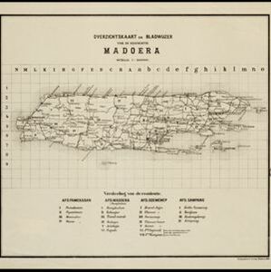
Overzichtskaart en bladwijzer van de residentie Madoera
1883
Indonesia
This overview map of the residency of Madoera (Madura Island, East Java, Indonesia) is divided into four regencies, and subdivided into 21 districts, which are numbered and listed at the bottom of the map. Major roads and settlements are also marked.


