Search

Search Results

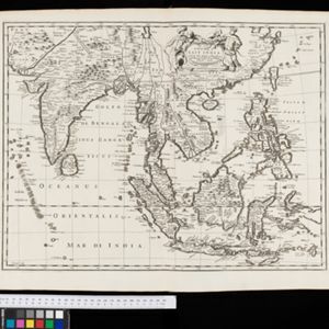
Asia with the islands adioyning described, the atire of the people, & townes of importance

eventc.1646-1657

location_onBrunei, Cambodia, East Timor, Indonesia, Laos, Malaysia, Myanmar, Philippines, Singapore, Southeast Asia, Thailand, Vietnam

This map is illustrated with drawings of Asian people wearing traditional clothing, including representatives of Sumatra, Java and the Maluku Islands. There are also drawings of important ports such as Bantam (Banten) at the western end of Java.

A new plaine and exact map of Asia

event1671

location_onBrunei, Cambodia, East Timor, Indonesia, Laos, Malaysia, Myanmar, Philippines, Singapore, Southeast Asia, Thailand, Vietnam

This colourful map of Asia is illustrated with drawings of Asian people wearing traditional clothing, including a man and woman from Java in Southeast Asia, and drawings of important ports such as Bantan (Banten) situated at the western end of Java.

A new map of East India

event1676

location_onBrunei, Cambodia, East Timor, Indonesia, Laos, Malaysia, Myanmar, Philippines, Singapore, Southeast Asia, Thailand, Vietnam

This colourful 17th century map highlights the mountain ranges and rivers of Southeast Asia and India. The cartouche features an illustration of Asian men wearing brightly-coloured clothing and carrying bows and arrows.

A New Map of East India

event1676

location_onMyanmar, Cambodia, Thailand, Vietnam, Brunei, Laos, Malaysia, Philippines, Indonesia, East Timor, Southeast Asia

This 17th century map of Asia is based on a map by the Dutch cartographer Frederik de Wit (c. 1629–1706). The text is in the original Latin, except for the title which has been changed to English. The original cartouche has also been retained.

Asia divided into its principall regions in which may be seen the extent of the Empires, Monarchies, Kingdoms and States which at present divide Asia

event1680

location_onBrunei, Cambodia, East Timor, Indonesia, Laos, Malaysia, Myanmar, Papua New Guinea, Philippines, Singapore, Southeast Asia, Thailand, Vietnam

This late 17th century map of Asia is by William Berry, based on an earlier map by the French cartographer Nicolas Sanson. Dedicated to King Charles II, it features the royal coat of arms of the United Kingdom in its elaborate cartouche.

The isles of Sonda

event1680

location_onBrunei, Indonesia, Malaysia, Singapore

From Robert Morden’s ‘Geography Rectified’, a description with maps of the known world in the late 17th century. Text describes the peoples of the uplands of the Sunda Islands as ‘Pagans’, while the coastal peoples are ‘Mahumetans [Muslims]’.

A new mapp of Asia: divided into kingdoms & provinces

event1690

location_onBrunei, Cambodia, East Timor, Indonesia, Laos, Malaysia, Myanmar, Philippines, Singapore, Southeast Asia, Thailand, Vietnam

A detailed late 17th century map of Asia, showing ancient kingdoms and the place names of important settlements. The cartouche features a drawing of Asian traders selling their goods, while a camel, monkey and two birds look on.

Hodiernæ Asiæ tabula

event1700

location_onBrunei, Cambodia, Indonesia, Laos, Malaysia, Myanmar, Papua New Guinea, Philippines, East Timor, Singapore, Southeast Asia, Thailand, Vietnam

The Latin title of this map translates as ‘Map of Today's Asia’, and reflects the knowledge of the region in the very early 18th century. Although lacking detail in Southeast Asia, the map does show the major islands and some cities.

To the Right Honourable William, Lord Cowper, Lord High Chancellor of Great Britain, this map of Asia

eventc.1715

location_onVietnam, Myanmar, Papua New Guinea, Philippines, Singapore, Southeast Asia, Thailand, Malaysia, Laos, Indonesia, East Timor, Cambodia, Brunei

The arrows on this map show the direction of the seasonal monsoons: each arrow has a label, indicating the month. The northeast coast of Borneo is labelled ‘A Desart [desert/deserted?] Coast’, while the south is labelled ‘Pepper Country’.

To the Right Honourable William, Lord Cowper, Lord High Chancellor of Great Britain, this map of Asia

event1715

location_onVietnam, Myanmar, Papua New Guinea, Philippines, Singapore, Southeast Asia, Thailand, Malaysia, Laos, Indonesia, East Timor, Cambodia, Brunei

This map is dedicated to William Cowper, whose coat of arms sits atop the cartouche. It features two horses holding a crest with three red martlets (mythical birds used in heraldry). The colourful cartouche also features Asian traders.

A map of the East-Indies and the adjacent countries: with the settlements, factories and territories, explaining what belongs to England, Spain, France, Holland, Denmark, Portugal &c.

event1717

location_onBrunei, Cambodia, East Timor, Indonesia, Laos, Malaysia, Myanmar, Philippines, Singapore, Southeast Asia, Thailand, Vietnam

This map showcases the colonial territories of Southeast Asia in the 18th century, with text detailing trading information and the products of each region. There are five inset maps featuring plans of specific trading ports.

close