
Search Results
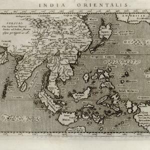
India orientalis
c.1597-1617
Brunei, Cambodia, East Timor, Indonesia, Laos, Malaysia, Myanmar, Philippines, Singapore, Southeast Asia, Thailand, Vietnam
Latin text written on New Guinea explains that it is uncertain whether it is an island or part of ‘Australis’ (‘southern land’) a name that was used for a continent thought to exist in the region (and after which Australia was eventually named).

Exacta & accurata delineatio cùm orarum maritimarum tùm etiam locorum terrestrium quae in regionibus China, Cauchinchina, Camboia sive Champa, Syao, Malacca, Aracan & Pegu
1596
Brunei, Cambodia, East Timor, Indonesia, Laos, Malaysia, Myanmar, Philippines, Singapore, Southeast Asia, Thailand, Vietnam
Unusually, north is located to the left of this map of East Asia, rather than the top. The text notes that shallows and reefs are marked, and that the map is based on the explorations of Portuguese ships. Illustrations include sea monsters and ships.
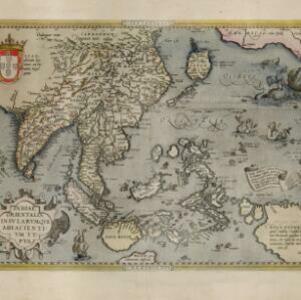
Indiae Orientalis insularumque adiacientium typus
c.1595-1601
Brunei, Cambodia, East Timor, Indonesia, Laos, Malaysia, Myanmar, Philippines, Singapore, Southeast Asia, Thailand, Vietnam
A white banner at the right features text that notes that the ‘Insule Molucce’ (Maluku Islands) are famous for their abundance of spices, which are sold across the world. There are also Illustrations of mermaids and sea monsters wrecking a ship.

Sumatra ein grosse Insel: so von den alten Geographen Taprobana genennet worden
c.1588-1628
Indonesia, Malaysia, Singapore, Thailand
A map of Sumatra featuring villages, mountains and rivers; text describing the island; and a drawing of a man riding an elephant. The title uses the name ‘Taprobana’ for Sumatra, stating it was a name used by ‘ancient geographers [alten geographen]’.
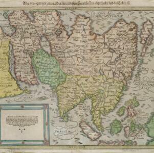
Asia wie es jetziger zeit nach den fuernemesten Herrschafften abgetheilet und beschriben ist
c.1588-1628
Brunei, Cambodia, East Timor, Indonesia, Laos, Malaysia, Myanmar, Philippines, Singapore, Southeast Asia, Thailand, Vietnam
This early German map of Asia is colour-coded by region, and features a brief description of Asia in blackletter German text. Interestingly, the Southeast Asian island of Sumatra is labelled 'Taprobana' which is the name the Greeks called Sri Lanka.
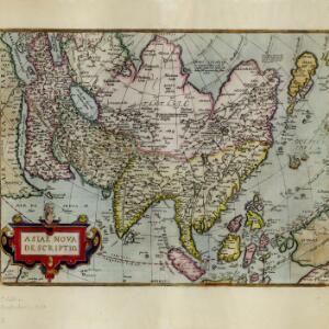
Asiae nova descriptio
c.1588-1612
Brunei, Cambodia, East Timor, Indonesia, Laos, Malaysia, Myanmar, Philippines, Singapore, Southeast Asia, Thailand, Vietnam
This late 16th/early 17th century map by Abraham Ortelius features a number of mythical lakes that were once thought to exist in southern China—including ‘Cayamay Lacus’—and which feed several rivers that flow south through mainland Southeast Asia.
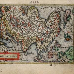
Asiae noŭa descr
c.1588-1590
Brunei, Cambodia, Indonesia, Laos, Malaysia, Myanmar, Philippines, Singapore, Southeast Asia, Thailand, Vietnam
This late 16th century map by Abraham Ortelius features a network of mythical lakes that were once thought to exist in China, and which feed several rivers that flow south through mainland Southeast Asia.


Indiae Orientalis insularumque adiacientium typus
1579
Brunei, Cambodia, East Timor, Indonesia, Laos, Malaysia, Myanmar, Philippines, Singapore, Southeast Asia, Thailand, Vietnam
A red banner at the right features text that notes that the ‘Insule Molucce’ (Maluku Islands) are famous for their abundance of spices, which are sold across the world. There are also Illustrations of mermaids and sea monsters wrecking a ship.

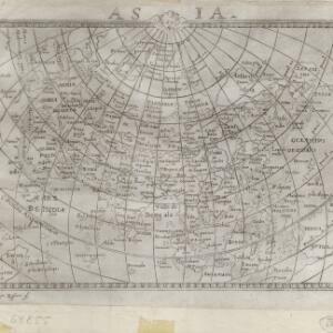
Tabvla Asiae XI
1574
Cambodia, Indonesia, Malaysia, Laos, Myanmar, Singapore, Thailand, Vietnam, Southeast Asia
Mid-16th century map by Girolamo Ruscelli, based on the work of 2nd century geographer Ptolemy. It is difficult to pinpoint exact locations, but the Malay Peninsula is recognisable. Italian text on the reverse describes the region.
- Malaysia126
- Indonesia121
- Singapore121
- Thailand109
- Cambodia104
- Vietnam102
- Myanmar100
- Brunei98
- Laos96
- Southeast Asia90
- Philippines89
- East Timor80
- more Simple Location »
- [remove]Malay Peninsula129
- Sumatra113
- Borneo93
- Java90
- Sulawesi73
- Celebes62
- Western New Guinea55
- Malacca54
- Pegu47
- Siam46
- Maluku Islands40
- Sunda Islands35
- more Detailed Location »


