
Search Results
585 Results found


Stanford's Library Map of Asia
1891
Brunei, Cambodia, East Timor, Indonesia, Laos, Malaysia, Myanmar, Philippines, Singapore, Southeast Asia, Thailand, Vietnam
Southeast Asia is on sheet four of this map. British colonial territory—British Burma, the Straits Settlements, Sarawak, British North Borneo—is highlighted in red, with the Dutch East Indies, Spanish Philippines and Portuguese East Timor also shown.


Map of the Kingdom of Siam and its dependencies
1888
Cambodia, Laos, Malaysia, Myanmar, Thailand, Vietnam
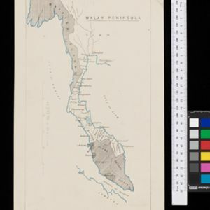
Map of the Kingdom of Siam, featuring mountains, rivers and villages, and surrounded by a yellow border (the border with Upper Burma and China in the north is undefined). The southern part of Siam is shown on an inset map of the Malay Peninsula.

India, Burmah and the adjacent parts of Beluchistan, Afghanistan, Turkestan, the Chinese Empire, and Siam
1887
Myanmar, Thailand, Malaysia, Indonesia
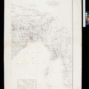
British Burma is shown on the right of this two-sheet map of India. The green areas had come under British rule after the first and second Anglo-Burmese wars, with Upper Burma (light brown) being incorporated after the Third Anglo-Burmese War (1885).

A sketch map of the East Indian possessions of the Netherlands
1886
Brunei, Indonesia, Malaysia, Papua New Guinea, Philippines, Singapore
Produced by the Intelligence Branch of the British War Office, this map shows Dutch colonial territories in maritime Southeast Asia, and their political and military divisions in Java and Madura. British and Spanish territories are also marked.

A map of the prevailing languages and dialects of India and its borders
1885
Myanmar, Thailand, Malaysia
A late 19th century map showing the languages and dialects spoken in and around India, including regions of Siam, Burma and Malaya. The regions are colour-coded by language and bordered by red lines to indicate different dialects.
India showing missionary stations
1884
Myanmar, Thailand, Malaysia, Singapore, Indonesia
This two-sheet map of India and Burma (Myanmar) shows missionary stations. The legend lists 29 European and 13 American missionary societies and churches, each with their own symbol to show their location on the map.

A Map of South Eastern Asia from Peking to Singapore... with an enlarged plan of the environs of Hanoi, on the Red River
1883
Brunei, Cambodia, Indonesia, Laos, Malaysia, Myanmar, Singapore, Thailand, Vietnam
Map of East Asia, with British colonial possessions—Burma, Straits Settlements, Labuan and British North Borneo—highlighted with red borders. There is also an inset map of the Red River (Hong River) running through Hanoi, Vietnam.
- Filter from 1478 to 1900
- Malaysia581
- Indonesia533
- Singapore524
- Thailand481
- Cambodia454
- Brunei451
- Vietnam440
- Myanmar439
- Laos415
- Philippines413
- East Timor392
- Southeast Asia374
- more Simple Location »
- [remove]Malay Peninsula585
- Sumatra514
- Borneo454
- Java429
- Sulawesi381
- Celebes317
- Western New Guinea286
- Siam265
- Maluku Islands240
- Malacca216
- South China Sea207
- Pegu190
- more Detailed Location »


