
Search Results


Algemeene kaart van Nederlandsch Oostindie
c.1839-1855
East Timor, Indonesia, Malaysia, Singapore
This map of the Dutch East Indies is spread over eight sheets, with a hand-drawn cover sheet showing the whole area. There are numerous inset maps of islands, bays, cities etc. Two of the inset maps have a replacement map pasted over them.

Nieuwe en naukeurige kaart der Oost-Indische Eilanden
c.1770
Brunei, Cambodia, East Timor, Indonesia, Laos, Malaysia, Myanmar, Philippines, Singapore, Southeast Asia, Thailand, Vietnam
Some regions on this map of Southeast have a descriptive label: Sumatra is described as having mines of gold, silver, iron, and sulphur; and elephants, tigers, rhinoceroses, dragons and crocodiles. Gilolo has rice, sago and turtles. Ambon has nutmeg.

Carte particuliere des isles Moluques
1750
Indonesia
A map of a small island chain off the west coast of the island of Gilolo (modern Halmahera in the Maluku Islands of Indonesia). The military forts on the islands were used by the European colonial powers during conflicts over the area’s spice trade.

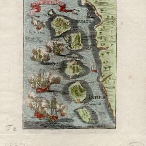
Les Îles Moluques, tres exactement representées selon les plus nouvelles Observations des meilleurs Geographes
c.1714-1729
Indonesia
A map of a small island chain off the west coast of the island of Gilola (modern Halmahera in the Maluku Islands of Indonesia). The military forts on the islands were used by the European colonial powers during conflicts over the area’s spice trade.


The Molucca Ilands &c.
c.1680-1700
East Timor, Indonesia, Philippines
From Robert Morden’s ‘Geography Rectified’, a description with maps of the known world in the late 17th century. The map shows the Moluccas, but the text describes the Philippines: Spanish colonial rule, trade, the city of Manila and port of Cavite.


