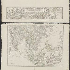
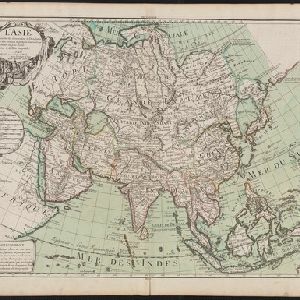
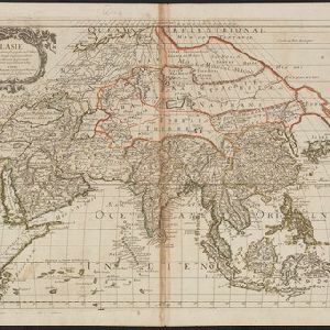
Search

Search Results

Asia

event1705

location_onBrunei, Cambodia, East Timor, Indonesia, Laos, Malaysia, Myanmar, Philippines, Singapore, Southeast Asia, Thailand, Vietnam

Map of Asia from the second volume of ‘Navigantium atque itinerantium bibliotheca: or, A compleat collection of voyages and travels: consisting of above four hundred of the most authentick writers’ published by John Harris in 1705.

Carte des Indes et de la Chine

event1705

location_onBrunei, Cambodia, East Timor, Indonesia, Laos, Malaysia, Myanmar, Philippines, Southeast Asia, Singapore, Thailand, Vietnam

An early 18th century map of Asia by the French cartographer Guillaume Delisle (1675–1726). Regions are indicated with coloured borders, and the southern part of Borneo is labelled ‘Côte de Mahometans [Coast of the Muslims]’.

L'Asie dressée sur les observations de l'Academie Royale des Sciences, et quelques autres, et sur les memoires les plus recens

event1700

location_onBrunei, Cambodia, East Timor, Indonesia, Laos, Malaysia, Myanmar, Philippines, Singapore, Southeast Asia, Thailand, Vietnam

This early 18th century map of Asia features a note stating that there are new features on this map not seen on previous maps, and that this is not a mistake. The cartouche features a column of Asian people riding on horses and camels.

Asia divided into its principall regions in which may be seen the extent of the Empires, Monarchies, Kingdoms and States which at present divide Asia

event1680

location_onBrunei, Cambodia, East Timor, Indonesia, Laos, Malaysia, Myanmar, Papua New Guinea, Philippines, Singapore, Southeast Asia, Thailand, Vietnam

This late 17th century map of Asia is by William Berry, based on an earlier map by the French cartographer Nicolas Sanson. Dedicated to King Charles II, it features the royal coat of arms of the United Kingdom in its elaborate cartouche.

L'Asie

event1669

location_onBrunei, Cambodia, East Timor, Indonesia, Laos, Malaysia, Myanmar, Philippines, Singapore, Southeast Asia, Thailand, Vietnam

Produced by the French cartographer Nicolas Sanson (1600–1667) in the mid-17th century, this map of Asia features hand-coloured regional borders. Its cartouche features cherubim and decorative scrollwork.

Carta secon[d]a generale del'Asia

event1646

location_onIndonesia, East Timor, Philippines

This mid-17th century map of the Philippines, Celebes (Sulawasi), Maluku Islands and New Guinea has some inaccuracies, particularly in the shape of Celebes and New Guinea. However, the many Philippine islands are portrayed relatively accurately.

Description de la coste septentrionale de Noua Guinea

event1618

location_onIndonesia

The north coast of New Guinea is mapped here as it was discovered by the Dutch explorer Willem Corneliszoon Schouten. He is named on the map as Guillaume Schouten de Hoorn, known as the first to sail from Europe to the Pacific Ocean via Cape Horn.

Description de la grande mer du Sud monstrant par quel chemin Guillaume Schouten a navige

event1618

location_onIndonesia, Papua New Guinea

This map shows the route of the Dutch explorer Willem Corneliszoon Schouten, crossing the Pacific Ocean from South America to New Guinea. He was the first explorer to sail from Europe to the Pacific Ocean via Cape Horn.

Description de la coste septentrionale de Noua Guinea

event1618

location_onIndonesia

The north coast of New Guinea is mapped here as it was discovered by the Dutch explorer Willem Corneliszoon Schouten. He is named on the map as Guillaume Schouten de Hoorn, known as the first to sail from Europe to the Pacific Ocean via Cape Horn.

Asiae nova descriptio

event1612

location_onBrunei, Cambodia, East Timor, Indonesia, Laos, Malaysia, Myanmar, Philippines, Singapore, Southeast Asia, Thailand, Vietnam

This early 17th century map features a number of mythical lakes that were once thought to exist in southern China—including ‘Cayamay Lacus’—and which feed several rivers that flow south through mainland Southeast Asia.

India Orien

event1607

location_onBrunei, Cambodia, East Timor, Indonesia, Laos, Malaysia, Myanmar, Philippines, Southeast Asia, Singapore, Thailand, Vietnam

Early 17th century map of Asia, with annotations in Latin naming the major countries, islands and cities. Maritime Southeast Asia is shown as an archipelago of many small islands.

Descriptio hydrographica accommodata ad battavorum navagatione in Javam insulam Indiæ Orientalis

event1601

location_onBrunei, Cambodia, East Timor, Indonesia, Laos, Malaysia, Myanmar, Philippines, Singapore, Southeast Asia, Thailand, Vietnam

This map shows the route of the first Dutch expedition to Southeast Asia in 1595-7. Led by Cornelis de Houtman, it was an attempt to enter the spice trade. The route crosses east over the Indian Ocean, circles the island of Java, and returns west.

close

  • Filter from 1550 to 1845

Current results range from 1550 to 1845