Search

Search Results

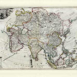
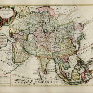
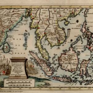
Carte des Indes, de la Chine & des Iles de Sumatra, Java &c.

event1719

location_onBrunei, Cambodia, East Timor, Indonesia, Laos, Malaysia, Myanmar, Philippines, Singapore, Southeast Asia, Thailand, Vietnam

Text on this map notes that Sumatra is divided into two equal parts by the Equator, so that the days and nights are always the same length. It also notes that Java is ruled by the Dutch, though the Mataram Sultanate in central Java is also mentioned.

Asiae recentissima delineatio, qua Status et Imperia totius Orientis unacum Orientalibus Indiis exhibentur

event1716

location_onVietnam, Myanmar, Papua New Guinea, Philippines, Singapore, Southeast Asia, Thailand, Malaysia, Laos, Indonesia, East Timor, Cambodia, Brunei

This map's cartouche features an illustration of three men bowing before an enthroned ruler. A second image is of a procession where a horned four-armed humanoid creature is being carried on poles by two bearers, while musicians follow behind.

To the Right Honourable William, Lord Cowper, Lord High Chancellor of Great Britain, this map of Asia

event1715

location_onVietnam, Myanmar, Papua New Guinea, Philippines, Singapore, Southeast Asia, Thailand, Malaysia, Laos, Indonesia, East Timor, Cambodia, Brunei

This map is dedicated to William Cowper, whose coat of arms sits atop the cartouche. It features two horses holding a crest with three red martlets (mythical birds used in heraldry). The colourful cartouche also features Asian traders.

Les Îles Moluques, tres exactement representées selon les plus nouvelles Observations des meilleurs Geographes

eventc.1714-1729

location_onIndonesia

A map of a small island chain off the west coast of the island of Gilola (modern Halmahera in the Maluku Islands of Indonesia). The military forts on the islands were used by the European colonial powers during conflicts over the area’s spice trade.

De Moluccos en andere Speceri-Eilanden in d'Oost-Indien

event1714

location_onIndonesia

Map of the ‘Spice Islands’ of maritime Southeast Asia, including the Maluku Islands. It is decorated with a drawing of an Asian man holding a large bird and a spear, and surrounded by baskets and boxes of goods of the spice trade.

Asia corrected from the observation communicated to the Royal Society at London and the Royal Academy at Paris

event1713

location_onBrunei, Cambodia, East Timor, Indonesia, Laos, Malaysia, Myanmar, Philippines, Singapore, Southeast Asia, Thailand, Vietnam

This early 18th century map of Asia features a drawing of a woman burning offerings on an altar, while two children carry cornucopias, and a camel looks on. The Roman god Mercury descends from the sky in the background wearing his winged helmet.

Asia: according to ye newest observations

event1713

location_onBrunei, Cambodia, East Timor, Indonesia, Laos, Malaysia, Myanmar, Philippines, Singapore, Southeast Asia, Thailand, Vietnam

This early 18th century map of Asia features a drawing of a woman burning offerings on an altar, while two children carry cornucopias, and a camel looks on. The Roman god Mercury descends from the sky in the background wearing his winged helmet.

India orientalis

event1713

location_onBrunei, Cambodia, East Timor, Indonesia, Laos, Malaysia, Myanmar, Philippines, Singapore, Southeast Asia, Thailand, Vietnam

This map is from ‘Universus terrarum orbis scriptorum calamo delineatus’ by Alphonsus Lasor a Varea (pseudonym of Raffaello Savonarola (1680–1748), a monk who worked in the monastery library in Padua).

L'Asie dresse sur les observations de l'Academie Royale des Sciences, et quelques autres, et sur les memoires les plus recens

event1708

location_onBrunei, Cambodia, East Timor, Indonesia, Laos, Malaysia, Myanmar, Philippines, Singapore, Southeast Asia, Thailand, Vietnam

This early 18th century map of Asia features a note stating that there are new features on this map not seen on previous maps, and that this is not a mistake. The colourful cartouche features a column of Asian people riding on horses and camels.

D' Indiaanze landschappen, zeen en eylanden, van Couchin af, tot in de Moluccos, en na by gelegen eylanden

event1707

location_onBrunei, Cambodia, East Timor, Indonesia, Laos, Malaysia, Myanmar, Philippines, Vietnam, Thailand, Southeast Asia, Singapore

The title cartouche of this early 18th century map of Southeast Asia is decorated with two drawings of battles. On the left, a sea battle with smoke rising from the ships’ cannons. On the right, an army attacks a walled city which is on fire.

Les isles Philippines et celles des Larrons ou de Marianes, les isles Moluques et de la Sonde, avec la presqu'isle de l'Inde de la le Gange ou orientale

event1706

location_onBrunei, Cambodia, East Timor, Indonesia, Laos, Malaysia, Myanmar, Philippines, Singapore, Southeast Asia, Thailand, Vietnam

This early 18th century map of Southeast Asia includes a list detailing the location (latitude and longitude) of seven important cities in the region: Batavia, Achem, Camboya, Siam, Borneo, Macaçar and Manilla.

Le Molucche

event1692

location_onIndonesia

Map of a small island chain off the west coast of Gilolo (modern Halmahera in the Maluku Islands, Indonesia). Italian text describes the larger islands (Ternate and Tidore) and the Philippines. From Vicenzo Coronelli's ‘Corso Geografico Universale’.

close

  • Filter from 1540 to 1855

Current results range from 1540 to 1855