
Search Results

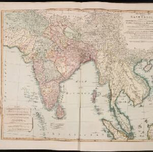
Kaart van Azië ten gebruike der scholen van het Koninkrijk der Nederlanden = Carte d'Asie, a l'usage des maisons d'éducation
1830
Brunei, Cambodia, East Timor, Indonesia, Laos, Malaysia, Myanmar, Philippines, Singapore, Southeast Asia, Thailand, Vietnam
Map of Asia spread over nine sheets, for use in schools. Place names are not printed on the map itself, but are represented by initials and numbers (presumably, there is a legend that lists the names, but it is not present).
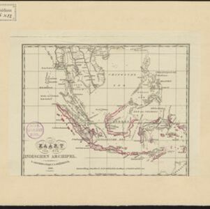
Kaart van den Indischen Archipel
1830
Brunei, Cambodia, East Timor, Indonesia, Laos, Malaysia, Myanmar, Philippines, Singapore, Southeast Asia, Thailand, Vietnam
This map shows the Dutch colonial possessions or dependencies in the East Indies during the early 19th century. Areas not coloured red remained under local rulers or were colonies of other European powers.

Kaart van Azië ten gebruike der scholen van het Koninkrijk der Nederlanden = Carte d'Asie, a l'usage des maisons d'éducation
1830
Brunei, Cambodia, East Timor, Indonesia, Laos, Malaysia, Myanmar, Philippines, Singapore, Southeast Asia, Thailand, Vietnam
Map of Asia spread over nine sheets, for use in schools. Place names are not printed on the map itself, but are represented by initials and numbers (presumably, there is a legend that lists the names, but it is not present).
Kaart van den Indischen Archipel
1830
Brunei, Cambodia, East Timor, Indonesia, Laos, Malaysia, Myanmar, Philippines, Singapore, Southeast Asia, Thailand, Vietnam
This map shows the Dutch colonial possessions or dependencies in the East Indies during the early 19th century. Areas not coloured red remained under local rulers or were colonies of other European powers.

East India Isles
1829
Brunei, Cambodia, East Timor, Indonesia, Laos, Malaysia, Myanmar, Vietnam, Thailand, Southeast Asia, Singapore, Philippines
From ‘Thomson’s New General Atlas’, this mid-19th century map was based on an earlier map by the English cartographer John Cary. It highlights the mountain ranges and rivers of Southeast Asia, and also features many place names.

Birman Empire
1829
Myanmar, Thailand, Laos, Vietnam, Cambodia
This map of the Burman Empire (Myanmar) features mountains, forests and rivers, as well as borders with Siam (Thailand) and Laos. Text notes how far up rivers boats can reach (‘Boats reach hither from the Sea’), ruby mines and rice fields.

Birman Empire
1824
Cambodia, Myanmar, Thailand, Vietnam, Laos
This map of the Burman Empire (Myanmar) features mountains, forests and rivers, as well as borders with Siam (Thailand) and Laos. Text notes how far up rivers boats can reach (‘Boats reach hither from the Sea’), ruby mines and rice fields.

Chart of the East India Islands: exhibiting the several passages between the Indian and Pacific Oceans
1824
Brunei, Cambodia, East Timor, Indonesia, Malaysia, Philippines, Singapore, Thailand, Vietnam, Southeast Asia, Myanmar
To aid navigation, this map shows small islands, shoals and reefs, maritime routes for use during monsoons or at particular times of the year, bathymetry (sea depth), past explorers’ routes, shipwrecks and text about monsoons, typhoons and currents.
A New general map of the East Indies, exhibiting in the Peninsula on this side of the Ganges or Hindoostan, the several partitions of the Mogul's Empire
1823
Malaysia, Brunei, Indonesia, Cambodia, Thailand, Vietnam, Myanmar, Laos, Southeast Asia
This 19th century map highlights British colonial possessions in India (in red), and the various kingdoms of northern Southeast Asia, including the Birman Empire (Myanmar), Cochin China and Tonkin (Vietnam), Lao (Laos), Siam (Thailand), and Cambodia.

Asien
c.1820
Brunei, Cambodia, East Timor, Indonesia, Laos, Malaysia, Myanmar, Papua New Guinea, Philippines, Singapore, Southeast Asia, Thailand, Vietnam
On this map of Asia, India and mainland Southeast Asia are labelled together as ‘Ost Indien [East Indies]’. In maritime Southeast Asia, the Sunda Islands are coloured yellow, the Maluku Islands and New Guinea are blue, and the Philippines are red.
- Filter from 1550 to 1894
- Myanmar233
- Thailand233
- [remove]Vietnam233
- Cambodia232
- Laos231
- Malaysia229
- Indonesia224
- Brunei220
- Singapore220
- Philippines219
- Southeast Asia207
- East Timor198
- more Simple Location »
- [remove]Pegu233
- Sumatra219
- Borneo213
- Java200
- Sulawesi183
- Malay Peninsula181
- Celebes170
- Siam158
- Malacca124
- Western New Guinea116
- Maluku Islands88
- Iava71
- more Detailed Location »


