Search

Search Results

Sketch map shewing progress of railway construction in the Federated Malay States

event1898

location_onMalaysia

Various stages of railway construction are shown on this map of the west coast of the Malay Peninsula, from stretches being surveyed to completed line. Costs are given for the construction.

New Sketch Map of the Protected Malay State of Perak

event1892

location_onMalaysia

Map of the state of Perak (Malay Peninsula) with a table of statistics: area, population, road/railway/river lengths, revenue, tin exports. Gold and tin mines are marked, and the Straits Settlements are highlighted in red.

New sketch map of the protected Malay State of Perak

event1892

location_onMalaysia

Map of state of Perak (Malay Peninsula) with a table of statistics: area, population, road/railway/river lengths, revenue, tin exports. Straits Settlements highlighted red. Someone has added handwritten travel times/distances by steamer/road/train.

Malay Peninsula

event1886

location_onMyanmar, Thailand, Malaysia

Map of the Malay Peninsula showing three British colonial territories: British Burmah, British Malaya (Perak, Selangore, Pahang, Johore) and the Straits Settlements (Pinang/Wellesley, Dindings, Malacca (Singapore not shown)).

Map of the Malay Peninsula

event1883

location_onMalaysia, Singapore

The Straits Settlements are in red, with the rest of the map marked with names of local peoples (‘Inhabited by the Johor Jakuns’) and resources (mines). Many areas are left blank or vague as unexplored or approximate. Inset map of Singapore city.

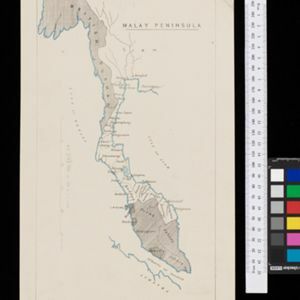
Map of the Malay Peninsula 1879

event1879

location_onMalaysia, Singapore, Thailand

Six-sheet map of the Malay Peninsula, featuring settlements, mountains and rivers. Labels note names of indigenous peoples, or describe terrain/resources. There is an inset map of Singapore town, and the Straits Settlements are highlighted in red.

Prèsqu'ile de Malacca

event1827

location_onMalaysia, Indonesia, Singapore

By Belgian geographer Philippe Vandermaelen (1795–1869), this 19th century map of the Malay Peninsula also features the Riau Islands—including the Anambas and Natuna islands in the South China Sea—the Straits of Malacca and the Singapore Strait.

close

  • Filter from 1827 to 1898

Current results range from 1827 to 1898