Search

Search Results

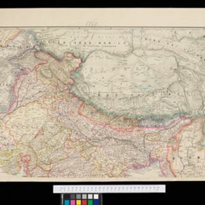
A map shewing the various routes proposed for connecting China with India and Europe through Burmah and developing the trade of Eastern Bengal, Burmah and China

event1875

location_onMyanmar, Thailand

A map of proposed trade routes through Burmah (modern Myanmar) intended to connect China to India and Europe. The border between India and Burmah is marked as being ‘unexplored’ and ‘undefined’. A table lists the distances between various cities.

Stanford's portable map of India shewing its present divisions and the adjacent parts of Beluchistan, Afghanistan, Turkestan, the Chinese Empire, Burmah and Siam

event1869

location_onMyanmar, Indonesia, Thailand

This two-sheet map of India includes Burma (Myanmar) and Siam. British Burma—which came under British colonial rule after the first (1824–1826) and second (1852–1853) Anglo-Burmese wars—is highlighted in red.

close

  • Filter from 1869 to 1875

Current results range from 1869 to 1875