
Search Results
Filter
Detailed Location
Sumatra
Remove constraint Detailed Location: Sumatra
Detailed Location
Sunda Islands
Remove constraint Detailed Location: Sunda Islands
Simple Location
Laos
Remove constraint Simple Location: Laos
Simple Location
Malaysia
Remove constraint Simple Location: Malaysia
Place of Publication
Gotha
Remove constraint Place of Publication: Gotha
3 Results found


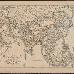
Asien gegen Ende des XVIIIten Jahrhunderts
c.1800-1899
Brunei, Cambodia, East Timor, Indonesia, Laos, Malaysia, Myanmar, Philippines, Singapore, Southeast Asia, Thailand, Vietnam
This map of Asia, from an atlas by the German cartographer Karl von Spruner, is colour-coded to show the possessions of the Indian Maratha Empire, and of the European colonial powers at the end of the 18th century.
- Filter from 1800 to 1890
- Java3
- Siam3
- South China Sea3
- [remove]Sumatra3
- Sunda Inseln3
- [remove]Sunda Islands3
- Anam2
- Birma2
- Borneo2
- Celebes2
- Chines Meer2
- Malacca2
- more Detailed Location »


