
Search Results
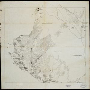

Schetskaart der voormalige Ooster-buitenlinie
1895
Indonesia
Produced during the Aceh War, the ‘Ooster-buitenlinie [Eastern outer line]’ of this map’s title probably refers to Dutch troop positions—marked with flag symbols—along the red road on the left. The road is east of the city of Kota Radja (Banda Aceh).


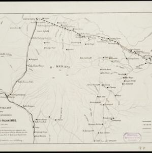
Overzichtskaart van den ontworpen spoorweg Fort de Kock-Pajakombo
1894
Indonesia
A map of railway lines between Fort de Kock (Bukittinggi) and Pajakombo (Payakumbuh) in western Sumatra. The map includes existing line, planned line and rack railway line (a line with a rack and pinion system so it can operate on steep slopes).

Trade Routes in the Far East
1894
Brunei, Cambodia, Indonesia, Laos, Malaysia, Myanmar, Philippines, Singapore, Thailand, Vietnam
Map of stream ship trade routes around Southeast Asia. Rivers, railways, submarine telegraph cables, lighthouses (fixed, revolving and flashing), graving docks and coaling stations are marked. An inset map shows a railway route from Britain to Asia.

Oostkust Sumatra. Schetskaart der Siak Rivier van het Eiland Tengah tot Siak
1894
Indonesia
This late 19th century large-scale (1:30,000) map show just a section of the Siak River, in the Riau province of Sumatra. Bathymetry (water depth) is shown in figures to aid navigation, with various landmarks noted along the river’s banks.

Zuidelijk gedeelte van de Chineesche zee: Blad I
1893
Malaysia, Indonesia, Singapore
Navigation map of the southern part of the South China Sea, including the straits of Malacca and Singapore, and the Riau Archipelago. Bathymetry (sea depth), lighthouses, shoals and other obstructions are marked, with hills to use as landmarks.

Noordwestkust Sumatra: Van Roesa to de Bocht van Pedir
1893
Indonesia
A navigation map of the northern tip of Sumatra, featuring bathymetry (sea depth), reefs, shoals, and side views of landmark mountains (elevations). Lighthouses are highlighted in red and yellow, with lines to indicate the limits of their range.
- Filter from 1535 to 1900
- Dutch248
- French199
- Latin182
- English169
- German76
- Italian27
- Spanish2
- Portuguese1
- more Language »
- [remove]Indonesia839
- Malaysia668
- Singapore642
- Brunei588
- Thailand587
- Cambodia565
- Vietnam551
- Myanmar547
- Philippines542
- Laos523
- East Timor512
- Southeast Asia500
- more Simple Location »
- [remove]Sumatra839
- Borneo613
- Java599
- Malay Peninsula513
- Sulawesi483
- Celebes411
- Western New Guinea327
- Maluku Islands312
- Siam307
- Sunda Islands252
- Malacca241
- Pegu226
- more Detailed Location »


