Search

Search Results

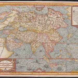
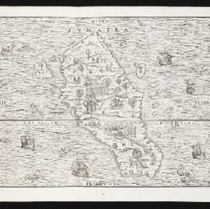
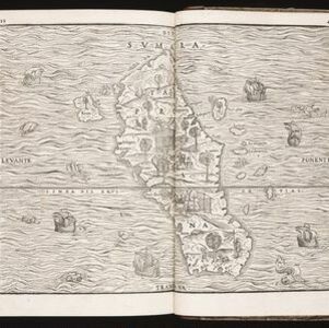
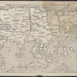
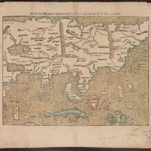
Nova tabula insularum Iavae, Sumatrae, Borneonis et aliarum Mallaccam usquae

event1601

location_onMalaysia, Indonesia, Singapore

Adapted by Theodore de Bry from an original by Willem Lodewycksz, this map has some inaccuracies e.g. the Malay Peninsula (‘Chersonese’) is completely bisected by the Muar River, leaving the southern tip of the peninsula as a separate island.

Exacta & accurata delineatio cum orarum maritimarum tum etiam locorum terrestrium quae in regionibus China, Cauchinchina, Camboia sive Champa, Syao, Malacca, Aracan & Pegu

event1598

location_onBrunei, Cambodia, East Timor, Indonesia, Laos, Malaysia, Myanmar, Philippines, Singapore, Southeast Asia, Thailand, Vietnam

Unusually, north is located to the left of this map of East Asia, rather than the top. The text notes that shallows and reefs are marked, and that the map is based on the explorations of Portuguese ships. Illustrations include sea monsters and ships.

Exacta & accurata delineatio cùm orarum maritimarum tùm etiam locorum terrestrium quae in regionibus China, Cauchinchina, Camboia sive Champa, Syao, Malacca, Aracan & Pegu

event1596

location_onBrunei, Cambodia, East Timor, Indonesia, Laos, Malaysia, Myanmar, Philippines, Singapore, Southeast Asia, Thailand, Vietnam

Unusually, north is located to the left of this map of East Asia, rather than the top. The text notes that shallows and reefs are marked, and that the map is based on the explorations of Portuguese ships. Illustrations include sea monsters and ships.

Exacta & accurata delineatio cùm orarum maritimarum tùm etiam locorum terrestrium quae in regionibus China, Cauchinchina, Camboia sive Champa, Syao, Malacca, Aracan & Pegu

event1595

location_onBrunei, Cambodia, East Timor, Indonesia, Laos, Malaysia, Myanmar, Philippines, Singapore, Southeast Asia, Thailand, Vietnam

Unusually, north is located to the left of this map of East Asia, rather than the top. The text notes that shallows and reefs are marked, and that the map is based on the explorations of Portuguese ships. Illustrations include sea monsters and ships.

Asie

event1575

location_onBrunei, Cambodia, East Timor, Indonesia, Laos, Malaysia, Myanmar, Philippines, Singapore, Southeast Asia, Thailand, Vietnam

A colourful 16th century map by André Thevet, with illustrations of ships and sea monsters around the seas of Southeast Asia. The map's scale is decorated with cartography tools such as rulers and a compass.

Sumatra

event1565

location_onIndonesia

This early map of Sumatra (labelled ‘Taprobana’) features many illustrations. In the sea, there are ships, fish and sea monsters, while on land, plantations, agricultural workers, a shepherd and wooden buildings highlight the economy of the island.

Sumatra

event1565

location_onIndonesia

This early map of Sumatra (labelled ‘Taprobana’) features many illustrations. In the sea, there are ships, fish and sea monsters, while on land, plantations, agricultural workers, a shepherd and wooden buildings highlight the economy of the island.

Sumatra

event1565

location_onIndonesia

This early map of Sumatra (labelled ‘Taprobana’) features many illustrations. In the sea, there are ships, fish and sea monsters, while on land, plantations, agricultural workers, a shepherd and wooden buildings highlight the economy of the island.

Tabula orientalis regionis, Asiae scilicet extremas complectens terras et regna

event1550

location_onBrunei, Cambodia, East Timor, Indonesia, Laos, Malaysia, Myanmar, Philippines, Singapore, Southeast Asia, Thailand, Vietnam

This 1550 map by the German cartographer Sebastian Münster (1488–1552) was based on the work of the 2nd century geographer Ptolemy. There are many inaccuracies, especially in scale and the locations of mountain ranges, but the region is recognisable.

Die Laender Asie nach ihrer Gelegenheit biss in Indiam, werden in dieser Tafeln verzeichnet

event1550

location_onCambodia, Indonesia, Laos, Malaysia, Philippines, Southeast Asia, Thailand, Vietnam, Myanmar, Brunei, East Timor, Singapore

This 1550 map by the German cartographer Sebastian Münster (1488–1552) was based on the work of the 2nd century geographer Ptolemy. There are many inaccuracies, especially in scale and the locations of mountain ranges, but the region is recognisable.

close

  • Filter from 1550 to 1900

Current results range from 1550 to 1900