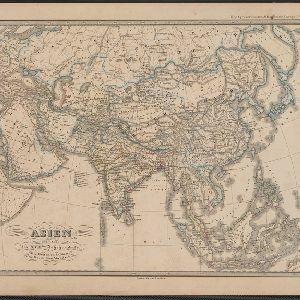
Search

Search Results

Asien

eventc.1820

location_onBrunei, Cambodia, East Timor, Indonesia, Laos, Malaysia, Myanmar, Papua New Guinea, Philippines, Singapore, Southeast Asia, Thailand, Vietnam

On this map of Asia, India and mainland Southeast Asia are labelled together as ‘Ost Indien [East Indies]’. In maritime Southeast Asia, the Sunda Islands are coloured yellow, the Maluku Islands and New Guinea are blue, and the Philippines are red.

East India Isles

event1817

location_onBrunei, Cambodia, East Timor, Indonesia, Laos, Malaysia, Myanmar, Vietnam, Thailand, Southeast Asia, Singapore, Philippines

This early 19th century map was based on an earlier map by the English cartographer John Cary. It highlights the mountain ranges and rivers of Southeast Asia, and also features many place names of cities, towns and islands.

Asia

eventc.1815-1817

location_onBrunei, Cambodia, East Timor, Indonesia, Laos, Malaysia, Myanmar, Papua New Guinea, Philippines, Singapore, Southeast Asia, Thailand, Vietnam

An early 19th century map, with the regions of Southeast Asia marked with different colours. Interestingly, Cambodia and modern Vietnam (labelled here as Cochinchina and Tonkin) are grouped with China.

Asia. Engraved for Evans's Geographical Grammar

event1809

location_onBrunei, Cambodia, East Timor, Indonesia, Laos, Malaysia, Myanmar, Papua New Guinea, Philippines, Singapore, Southeast Asia, Thailand, Vietnam

This early 19th century map depicts the regions of Asia by colour. The continental regions are green, while the archipelago regions are red, except for New Guinea which is yellow.

The continent and islands of Asia: with all the latest discoveries

event1809

location_onVietnam, Myanmar, Papua New Guinea, Philippines, Singapore, Southeast Asia, Thailand, Malaysia, Laos, Indonesia, East Timor, Cambodia, Brunei

Southeast Asia is on the last sheet of this map of Asia. The South China Sea is labelled ‘Malayan Sea’. Small islands, shoals and reefs are shown. A label in Cochin China (Vietnam) reads ‘mountains inhabited by the uncivilized people called Kemoys’.

Carte de l'Archipel des Indes Orientales, représentant les différens passages entre l'Ocean Indien et le Grand Océan

eventc.1804

location_onBrunei, Cambodia, East Timor, Indonesia, Laos, Malaysia, Myanmar, Philippines, Singapore, Southeast Asia, Thailand, Vietnam

Map focusing on the passages between the islands of maritime Southeast Asia used to travel between the Indian and Pacific oceans. Includes the Strait of Malacca, many straits between the Sunda Islands, and a route through the Maluku Islands.

The Eastern Hemisphere

event1801

location_onMyanmar, Brunei, Cambodia, East Timor, Indonesia, Laos, Malaysia, Vietnam, Thailand, Southeast Asia, Singapore, Philippines

Published by the English cartographer John Cary (c.1754–1835), this map is marked with the routes taken from Europe to Asia by the British Royal Navy captains James Cook, John Gore, and George Vancouver, as well as the French explorer Lapérouse.

Charte de l'Asie

event1800

location_onBrunei, Cambodia, East Timor, Indonesia, Laos, Malaysia, Myanmar, Papua New Guinea, Philippines, Singapore, Southeast Asia, Thailand, Vietnam

The cartouche on this early 19th century map of Asia features a drawing of an Asian merchant smoking a long pipe while standing with his goods. Behind are a camel and an elephant surrounded by greenery and palm trees.

Asien gegen Ende des XVIIIten Jahrhunderts

eventc.1800-1899

location_onBrunei, Cambodia, East Timor, Indonesia, Laos, Malaysia, Myanmar, Philippines, Singapore, Southeast Asia, Thailand, Vietnam

This map of Asia, from an atlas by the German cartographer Karl von Spruner, is colour-coded to show the possessions of the Indian Maratha Empire, and of the European colonial powers at the end of the 18th century.

East Indies

eventc.1800-1899

location_onBrunei, Cambodia, East Timor, Indonesia, Laos, Malaysia, Myanmar, Philippines, Singapore, Southeast Asia, Thailand, Vietnam

Longitude is indicated in two different ways on this mid-18th century map: along the top border, it is shown in degrees (number of degrees east of London); more unusually, along the bottom border, it is shown in time (number of hours east of London).

close