
Search Results


[Verzamelkaart van door uitbarsting en vloedgolf verwoeste gebieden]
1883
Indonesia
Nine maps of the effects of the 1883 Krakatoa volcanic eruption, including on Rakata Island itself, and Calmeyer Island (formed by the eruption). Other maps use brown shading to show the flooding of nearby islands and settlements by ensuing tsunamis.

Kaart van Krakatau en omliggende eilanden
1883
Indonesia
A map of the effects of the 1883 Krakatoa volcanic eruption. The orange line is the islands’ outline pre-eruption; the red line is the boundary of the collapsed area. Red numbers are sea depth. Pre- and post-eruption sizes of the islands are listed.

Western part of the Java Sea : from Lucipara I. to Sunda Strait and Batavia
1866
Indonesia
Designed to aid navigation around the western Java Sea, this map features bathymetry (sea depth), current and tide data, and is marked with shoals, reefs and other hazards. Written notes add details at specific locations (e.g. ‘heavy tide rips’).

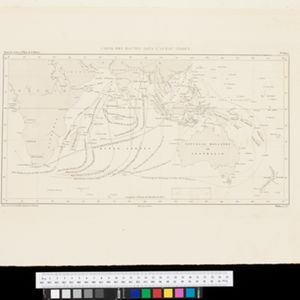
Carte des Routes dans l'Océan Indien
c.1849-1863
Brunei, Cambodia, East Timor, Indonesia, Laos, Malaysia, Myanmar, Papua New Guinea, Philippines, Singapore, Southeast Asia, Thailand, Vietnam
Map of the Indian Ocean showing maritime routes, including some to and around Southeast Asia, where they pass through the Strait of Malacca, the Sunda Strait, and the straits between the Lesser Sunda Islands.

A chart of the Indian and Pacific Oceans with particular plans of the harbours
1847
Brunei, Cambodia, East Timor, Indonesia, Laos, Malaysia, Myanmar, Papua New Guinea, Philippines, Southeast Asia, Singapore, Thailand, Vietnam
Southeast Asia is shown on sheets two and three of this 12-sheet map of the Indian and Pacific oceans, including detailed inset maps of the straits of Singapore, Bangka, Gaspar and Sunda, with bathymetry (sea depth), shoals, reefs, anchorages etc.

Reduzirte Karte vom Sunda- oder Borneo-Meere
1835
Indonesia, Malaysia
A navigation map of the Java Sea and Sunda Islands, with bathymetry (sea depth), maritime routes, shoals and reefs, and elevations (side views of terrestrial landmarks). Inset maps feature the bay at Batavia and the straits between the Sunda Islands.

Reduzirte Karte vom Sunda- oder Borneo-Meere
1835
Malaysia, Indonesia
A navigation map of the Java Sea and Sunda Islands, with bathymetry (sea depth), maritime routes, shoals and reefs, and elevations (side views of terrestrial landmarks). Inset maps feature the bay at Batavia and the straits between the Sunda Islands.
- Filter from 1590 to 1883
- [remove]Sunda Strait56
- Java50
- Sumatra45
- Borneo25
- Java Sea17
- Batavia16
- Jakarta15
- Malay Peninsula15
- Strait of Malacca15
- Sulawesi14
- Siam12
- Sunda Islands12
- more Detailed Location »


