Search

Search Results

Java

event1894

location_onIndonesia

This detailed late 19th century map shows Java divided into regencies, and features mountains, land and sea routes, and an inset map of the port city of Batavia (Jakarta). It was designed to be folded within book covers so it could be easily carried.

Kaart van den gemiddelden regenval op Java, tevens situatie-schets van de djati- en wildhoutbosschen

event1892

location_onIndonesia

This late 19th century map records the average rainfall at a variety of locations—marked with blue dots—on Java. Three types of forest are also shown: cultivated forest, wild forest under management, and wild forest not under management.

Java

event1890

location_onIndonesia

This detailed late 19th century map shows Java divided into regencies, and features settlements, roads, railways, rivers, and maritime routes. There is also an inset map of the Kangean Islands.

Java

event1890

location_onIndonesia

This detailed late 19th century map shows Java divided into regencies, and features mountains, roads, railways, and rivers. There is also an inset map of the port city of Batavia (Jakarta).

Etappe-kaart van Java en Madoera

event1878

location_onIndonesia

This detailed map of Java and Madura covers four sheets, showing natural features (mountains, lakes, rivers, bays), residential areas (cities, towns, villages) and routes (railways, roads, sea routes). An inset map shows telegraph lines and offices.

Java en Madoera

event1875

location_onIndonesia

This detailed late 19th century map shows Java and Madura divided into regencies, and features mountains, roads, railways, and rivers.

Java en Madoera

event1873

location_onIndonesia

This detailed late 19th century map shows Java and Madura divided into regencies, and features mountains, roads, railways, and rivers.

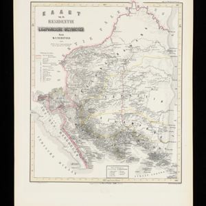
Kaart van de Residentie Lampongsche Districten

event1860

location_onIndonesia

Map of the Dutch colonial administrative region (residency) of Lampung at the southern tip of Sumatra, divided into five regencies (yellow borders). (From ‘Algemeene Atlas van Nederlandsche Indie [General Atlas of the Dutch East Indies]’.)

Kaart van het eiland Java

event1855

location_onIndonesia

Detailed map of Java based on the expeditions of the geologist and botanist Dr. Franz Junghuhn. There are 16 inset maps featuring volcanoes, mountains and coal seams.

Kaart van het eiland Java uit de nieuwste bronnen zamengesteld

event1855

location_onIndonesia

Map of Java divided into administrative areas (‘residencies’ and ‘regencies’). Mountains are represented by hachures, short lines/dashes that give a sense of the shape and steepness of terrain. Postal routes and roads are also marked.

close