
Search Results


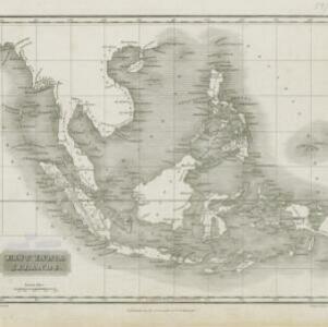
Map of South-Eastern Asia and Northern Australia: showing the districts in Annam and Tonquin which France proposes to annex and to place under a Protectorate, the portion of New Guinea proposed to be acquired by Queensland, and the districts affected by the volcanic eruptions in Java
1883
Southeast Asia, Singapore, Thailand, East Timor, Vietnam, Brunei, Cambodia, Indonesia, Laos, Malaysia, Myanmar, Papua New Guinea, Philippines


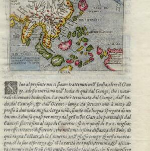
A map of the East-Indies and the adjacent countries: with the settlements, factories and territories, explaning what belongs to England, Spain, France, Holland, Denmark, Portugal &c.
1720
Brunei, Cambodia, East Timor, Indonesia, Laos, Malaysia, Myanmar, Philippines, Vietnam, Thailand, Southeast Asia, Singapore


- East Timor12
- Indonesia12
- [remove]Philippines12
- Brunei11
- Malaysia11
- Singapore11
- Cambodia10
- Laos10
- Myanmar10
- Southeast Asia10
- Thailand10
- Vietnam10
- more Simple Location »
- [remove]Western New Guinea12
- Borneo11
- Celebes11
- Java11
- Sulawesi11
- Sumatra11
- Malay Peninsula10
- Maluku Islands6
- Siam6
- South China Sea6
- Java Sea5
- New Guinea5
- more Detailed Location »


