Search

Search Results

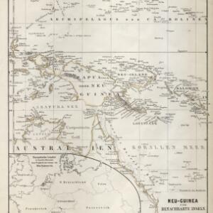
Neu-Guinea und benachbarte Inseln

event1869

location_onPapua New Guinea, Indonesia

From August Petermann's ‘Geographische Mittheilungen’, this map of New Guinea and neighbouring islands is marked with a maritime route from the western tip of New Guinea that is labelled ‘from Batavia to Hong Kong in 35 days’ and dated 1846.

Asiatic archipelago

event1858

location_onVietnam, Myanmar, Papua New Guinea, Philippines, Singapore, Southeast Asia, Thailand, Malaysia, Laos, Indonesia, East Timor, Cambodia, Brunei

This late 19th century map of Southeast Asia shows the best maritime routes around the region, according to the time of year. There are also inset maps highlighting the rivers and southern islands of Singapore, and the sea depth around Labuan Island.

Malay Archipelago, or East India Islands

event1851

location_onBrunei, Cambodia, East Timor, Indonesia, Laos, Malaysia, Myanmar, Papua New Guinea, Philippines, Singapore, Southeast Asia, Thailand, Vietnam

This mid-19th century map of Southeast Asia is illustrated with drawings of indigenous people from New Guinea, a ‘bee bear’ (probably a sun bear), a sailboat in front of Victoria Mount in New Guinea, and a village and palm trees in Sarawak, Borneo.

Asia

event1850

location_onBrunei, Cambodia, East Timor, Indonesia, Laos, Malaysia, Myanmar, Papua New Guinea, Philippines, Singapore, Southeast Asia, Vietnam, Thailand

This map is decorated with colourful illustrations of people and animals. Of particular interest to Southeast Asia are the paintings of 'Sun-birds of India and the Philippine Isles'.

Asiatic archipelago

event1840

location_onVietnam, Myanmar, Papua New Guinea, Philippines, Singapore, Southeast Asia, Thailand, Malaysia, Laos, Indonesia, East Timor, Brunei, Cambodia

This late 19th century map of Southeast Asia shows the best maritime routes around the region, according to the time of year. There is also an inset map highlighting the rivers and southern islands of Singapore.

Asiatic archipelago

event1832

location_onVietnam, Myanmar, Papua New Guinea, Philippines, Singapore, Southeast Asia, Thailand, Malaysia, Laos, Indonesia, East Timor, Cambodia, Brunei

This late 19th century map of Southeast Asia shows the best maritime routes around the region, according to the time of year. There is also an inset map highlighting the rivers and southern islands of Singapore.

East India Islands

event1817

location_onBrunei, Cambodia, East Timor, Indonesia, Laos, Malaysia, Myanmar, Philippines, Singapore, Southeast Asia, Thailand, Vietnam

Although there is not much detail on this early 19th century map of Southeast Asia, in addition to place names, some rivers and ports are named, and there is even a ‘Dutch Factory’ on the west coast of Malaya.

Asia

eventc.1815-1817

location_onBrunei, Cambodia, East Timor, Indonesia, Laos, Malaysia, Myanmar, Papua New Guinea, Philippines, Singapore, Southeast Asia, Thailand, Vietnam

An early 19th century map, with the regions of Southeast Asia marked with different colours. Interestingly, Cambodia and modern Vietnam (labelled here as Cochinchina and Tonkin) are grouped with China.

The Eastern Hemisphere

event1801

location_onMyanmar, Brunei, Cambodia, East Timor, Indonesia, Laos, Malaysia, Vietnam, Thailand, Southeast Asia, Singapore, Philippines

Published by the English cartographer John Cary (c.1754–1835), this map is marked with the routes taken from Europe to Asia by the British Royal Navy captains James Cook, John Gore, and George Vancouver, as well as the French explorer Lapérouse.

Les Isles de la Sonde, Moluques, Philippines, Carolines, et Mariannes

event1795

location_onBrunei, Cambodia, East Timor, Indonesia, Laos, Malaysia, Myanmar, Philippines, Singapore, Southeast Asia, Thailand, Vietnam

This map of the Sunda Isles (‘Isles de la Sonde’) (with red borders) and Maluku Islands (‘Isles Moluques’) (green borders) also includes mainland Southeast Asia (blue borders), the Philippines (yellow borders) and New Guinea (green borders).

Asia and its islands according to D'Anville: divided into empires, kingdoms, states, regions, &ca.

event1794

location_onBrunei, Cambodia, Indonesia, East Timor, Laos, Malaysia, Myanmar, Papua New Guinea, Philippines, Singapore, Thailand, Vietnam, Southeast Asia

This late 18th century map features a number of labels describing the local populations, including the Kemoys ('Savage People') of the mountains of Cokin China (Vietnam), the Biayos of Borneo, and the 'Wild People' of the mountains of Pegu (Myanmar).

The East India Islands: comprehending the Isles of Sunda, the Moluccas and the Philippine Islands

event1789

location_onBrunei, Cambodia, East Timor, Indonesia, Laos, Malaysia, Myanmar, Philippines, Singapore, Southeast Asia, Thailand, Vietnam

Labels on this late 18th century map of Southeast Asia describe two indigenous populations—the ‘Kemoy’ of the mountains along the border of Cochin China (Vietnam) and Camboja (Cambodia), and the ‘Biayos’ of central Borneo—as ‘a wild Nation’.

close

  • Filter from 1579 to 1869

Current results range from 1579 to 1869