Search

Search Results

Topographische kaart der residentie Semarang

event1898

location_onIndonesia

The residency of Semarang, Central Java, featuring crops (coffee, rice, bamboo, nipa palm); cemeteries, post offices, railway stations; routes (railway, postal, road, canal), administrative borders; mountains, rivers, forests.

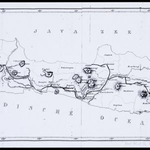
Atlas van Nederlandsch Oost-Indië

eventc.1897-1904

location_onIndonesia

Very detailed atlas of the entire Dutch East Indies, over 16 map sheets, with a cover and overview map. Includes topographic maps, inset maps of cities and islands, and maps featuring land and sea routes, languages, geology, colonial territory etc.

Topographische kaart der residentie Soerabaja

event1895

location_onIndonesia

The residency of Soerabaja, East Java, featuring crops (coffee, coconut, sugarcane, rice, alang-alang, bamboo) and fishing ponds. Three inset maps: a triangulation map; a map of distances between settlements by types of transport; Bawean Island.

Topographische kaart van de residentie Preanger regentschappen

event1894

location_onIndonesia

The residency of Preanger (Parahyangan), West Java, with plantations (coconut, coffee, tea, cinchona (‘kina’), betel, teakwood, bamboo) and crops (rice, sugarcane, alang-alang). Two inset maps: a triangulation map, and a map of land route distances.

Kaart van Java en Madura

event1885

location_onIndonesia

This map of Java and Madura is divided into administrative areas: residencies (blue lines), departments (green) and districts (yellow). The locations of government coffee and salt warehouses, as well as railways and tramways (red lines) are marked.

Kaart van Deli: Afdeeling der residentie Oostkusst van Sumatra

event1884

location_onIndonesia

Map of Deli on the east coast of Sumatra, dominated by the numerous rivers that flow from the mountains in the southwest to the Strait of Malacca. The railway lines around the city of Medan are shown in red, and flags indicate a military garrison.

Topographische kaart der residentie Soerabaja

event1884

location_onIndonesia

The residency of Soerabaja, East Java, featuring crops (coffee, coconut, sugarcane, rice, alang-alang, bamboo) and fishing ponds. Three inset maps: a triangulation map; a map of distances between settlements by types of transport; Bawean Island.

Overzichtskaart van Groot-Atjeh

event1884

location_onIndonesia

Map of Groot-Atjeh (Aceh, Sumatra) divided into administrative districts. Mountains, forests, villages, railways, roads and rivers are marked. There are inset maps of Poeloe Bras (Breueh Island), and showing distances between larger settlements.

Topographische kaart der residentie Soerakarta

event1867

location_onIndonesia

The residency of Soerakarta (Surakarta), Central Java, featuring crops (coffee, sugarcane, rice, sugar); warehouses (coffee, sugar, tobacco, indigo plant); factories (sugar, tobacco, indigo plant); routes (railway, postal, road).

Eiland Java: aanwijzing der geprojecteerde Spoorweglijnen

event1863

location_onIndonesia

The thick black lines on this map represent proposed routes for new railway lines in mid-19th century Java. The island is divided into administrative regions, with significant mountains and rivers marked.

close

  • Filter from 1863 to 1898

Current results range from 1863 to 1898