
Search Results

Kaart van de residentie Wester-afdeeling van Borneo
1898
Indonesia
Topographical map of western Borneo. Larger settlements are marked with their height above sea-level and with a flag to indicate a military garrison. They also have a letter signifying the local ruler, from Sultan to Lauthai (village elder).


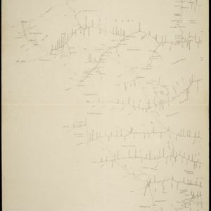
Kaart van het gebied bezet in Groot-Atjèh
1898
Indonesia
A large-scale map of Groot-Atjceh, northern Sumatra, spread over six sheets, and featuring details such as routes, crops (rice, banana, sugarcane, alang-alang, bamboo), mountains and wetlands, and settlements (city of Kota Radja (modern Banda Aceh)).

Karte des Mahakam-Flusses in Borneo: Nach den aufnahme der Niederländischen Expedition zur Durchquerung Borneo's, 1896-1897
1898
Indonesia, Malaysia
Map of the Mahakam River in Borneo, based on an expedition by the Dutch explorer Dr. Anton Nieuwenhuis in the late 19th century. An inset map shows the upper reaches of the river at twice the scale of the main map.

Kaart van 't noordwestelijke gedeelte der Residentie Ambon
1898
Indonesia
Map of the residency of Ambon in the Maluku Islands, divided by colour-coded administrative borders. There are inset maps the Banda Islands—including the nutmeg plantations and the town of Neira with its fort and hospital—and of Dutch New Guinea.


Geologische übersichts- und vulkan-karte von Java und Madura
1898
Indonesia
Geological map of Java and Madura, showing rock types and the locations of volcanoes. There are two cross sections (elevations) showing the heights of terrain: one of Java; and one from Cambodia to the Indian Ocean, including Borneo and Java.


- Filter from 1522 to 1900
- Dutch597
- French255
- English228
- Latin216
- German101
- Italian32
- Spanish3
- Portuguese1
- more Language »
- [remove]Indonesia1,345
- Malaysia737
- Singapore676
- Brunei621
- Thailand615
- Cambodia594
- Vietnam588
- Philippines583
- Myanmar573
- East Timor558
- Laos549
- Southeast Asia521
- more Simple Location »
- Java845
- Sumatra839
- Borneo687
- Sulawesi553
- Malay Peninsula533
- Celebes475
- Dutch East Indies467
- Maluku Islands373
- Western New Guinea359
- Siam316
- Sunda Islands279
- Malacca247
- more Detailed Location »
- Port166
- Pier74
- Railway Station49
- River934
- Road325
- Path187
- Railway/Tramway121
- Postal Route97
- Canal72
- Bridge50
- Telegraph/Telephone40
- Legend493
- Cartouche386
- Illustration326
- Inset Map286
- Elevation126
- Coat of Arms108


