
Search Results


Map to illustrate the Siamese question: showing the present limits of French claims, and the additional territory now demanded
1893
Cambodia, Laos, Malaysia, Myanmar, Thailand, Vietnam
Map highlighting areas of eastern Siam (Thailand) claimed by France. Notes describe Siam’s geography, government, population, military and trade (rice, teak, pepper, bullocks, fish, hides, tin, cardamom, tin), including trading partners by tonnage.


Stanford's Library Map of Asia
1891
Brunei, Cambodia, East Timor, Indonesia, Laos, Malaysia, Myanmar, Philippines, Singapore, Southeast Asia, Thailand, Vietnam
Southeast Asia is on sheet four of this map. British colonial territory—British Burma, the Straits Settlements, Sarawak, British North Borneo—is highlighted in red, with the Dutch East Indies, Spanish Philippines and Portuguese East Timor also shown.


Map of the Kingdom of Siam and its dependencies
1888
Cambodia, Laos, Malaysia, Myanmar, Thailand, Vietnam
Map of the Kingdom of Siam, featuring mountains, rivers and villages, and surrounded by a yellow border (the border with Upper Burma and China in the north is undefined). The southern part of Siam is shown on an inset map of the Malay Peninsula.

Malay, or East Indian Archipelago, with Burmah, Siam &c.
1887
Brunei, Cambodia, East Timor, Indonesia, Laos, Malaysia, Myanmar, Philippines, Singapore, Southeast Asia, Thailand, Vietnam
On this map of Southeast Asia, numerous small islands, shoals and reefs are marked and named, especially in the South China Sea and around the Sunda and Maluku islands. Submarine cables to carry telegraph messages around the region are also shown.
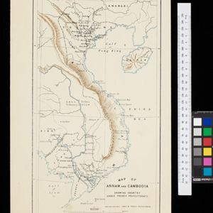
Map of Annam and Cambodia showing country under French protectorate
1885
Cambodia, Laos, Thailand, Vietnam
Map showing the French protectorate territories of mainland Southeast Asia: Annam, Tongking and French Cochin China (modern Vietnam) and Cambodia. Some parts of Siam (Thailand) and Laos are also shown.

Map of South-Eastern Asia and Northern Australia: showing the districts in Annam and Tonquin which France proposes to annex and to place under a Protectorate, the portion of New Guinea proposed to be acquired by Queensland, and the districts affected by the volcanic eruptions in Java
1883
Southeast Asia, Singapore, Thailand, East Timor, Vietnam, Brunei, Cambodia, Indonesia, Laos, Malaysia, Myanmar, Papua New Guinea, Philippines
This 1883 map shows European colonial territories in Southeast Asia. An inset map details the proposed French annexation of Tonquin, Annam and Cochin China (modern Vietnam). International telegraph lines are also marked.

Wereldkaart volgens Mercator's projectie
1883
Brunei, Cambodia, East Timor, Indonesia, Laos, Malaysia, Myanmar, Papua New Guinea, Philippines, Singapore, Southeast Asia, Thailand, Vietnam
A map charting the effects of the 1883 Krakatoa volcanic eruption: a red circle where the eruption was heard; black lines showing the hourly spread of the resulting waves; and a list of ships on which ash fell, or that encountered pumice (with date).
- Filter from 1478 to 1900
- Latin174
- English159
- French149
- German71
- Dutch65
- Italian18
- Portuguese1
- Russian1
- more Language »
- [remove]Laos593
- [remove]Vietnam593
- Thailand592
- Cambodia589
- Myanmar586
- Malaysia573
- Indonesia549
- Singapore548
- Brunei525
- Philippines518
- Southeast Asia502
- East Timor467
- more Simple Location »
- Sumatra525
- Borneo505
- Java457
- Malay Peninsula415
- Sulawesi404
- Celebes341
- Siam299
- Western New Guinea290
- Maluku Islands276
- Pegu231
- Sunda Islands214
- Malacca201
- more Detailed Location »


