
Search Results


Carte hydro-geo-graphique des Indes orientales, en deca̧ et au dela du Gange avec leur archipel
1771
Brunei, Cambodia, East Timor, Indonesia, Laos, Malaysia, Myanmar, Philippines, Singapore, Southeast Asia, Thailand, Vietnam
The arrows on this map show the direction of the seasonal monsoons of Southeast Asia during the late 18th century. Each arrow has a label in French, indicating the month. The hatched sea areas are where the winds always blow in the same direction.

L'Asie divisée en ses principaux Etats
c.1770
Brunei, Cambodia, East Timor, Indonesia, Laos, Malaysia, Myanmar, Philippines, Singapore, Southeast Asia, Thailand, Vietnam
This map shows the empires and kingdoms of Asia. Its decorative cartouche features a drawing of a censer (incense burner) standing on a plinth, surrounded by patterned curtains and carpet. Magellan’s discovery of the Philippines is noted on the map.

Isles de la Sonde
1767
Brunei, Indonesia, Malaysia, Singapore
Three of the larger Sunda Islands—Sumatra, Java and Borneo—are shown on this mid-18th century map, along with a few of the smaller islands such as Bali, Lombok and Sumbawa. Celebes (Sulawesi) and some of the other smaller islands are not included.


Carte des Isles de Java, Sumatra, Borneo &c. Les détroits de la Sonde, Malaca et Banca, Golfe de Siam &c.
1764
Brunei, Cambodia, Indonesia, Malaysia, Singapore, Thailand, Vietnam, Philippines
This map shows the islands of Java, Sumatra and Borneo, the straits of Sunda, Malacca and Bangka, and the Gulf of Siam. The points of the compass can be seen radiating out from a central compass rose.

Karte von dem eylande Sumatra nach den tagebüchern der schiffer
1764
Malaysia, Indonesia, Singapore
The title of this mid-18th century map of Sumatra and the Malay Peninsula claims that it was based on the diaries of sailors. Interestingly, the title is repeated in both German and French, as are the names of some of the locations marked on the map.

L'Asie Divisée en ses Grandes Régions et Empires: Subdivisée en ses Principaux Estats
1759
Brunei, Cambodia, East Timor, Indonesia, Laos, Malaysia, Myanmar, Philippines, Singapore, Southeast Asia, Thailand, Vietnam
Map of the regions, empires and states of Asia. Extensive notes cover religion (people of mainland Southeast Asia are idolaters), colonialism (Dutch and Portuguese rule in Malacca and the Sunda Islands) and the spice trade of the Maluku Islands.
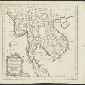
Carte de l'Inde au-delà du Gange comprenant les Royaumes de Siam, de Tunquin, Pegu, Ava, Aracan &c.
c.1757
Cambodia, Laos, Malaysia, Myanmar, Thailand, Vietnam
The kingdoms of mid-18th century mainland Southeast Asia are shown on this map: Ava and Pegu (Myanmar), Siam (Thailand), Tonquin and Cochinchine (Vietnam), Camboie (Cambodia) and Laos. Rivers are also prominent, and mountains are shown pictorially.

Carte réduite des détroits de Malaca, Sincapour, et du Gouverneur
1755
Malaysia, Singapore, Indonesia
Maps like this aided navigation through the islands, shoals and reefs of Singapore and the Malacca Strait. Three routes around Singapore are shown, numbers on the sea indicate water depth, and the profile views of mountains were used as landmarks.
- [remove]Malaysia90
- Indonesia83
- Thailand74
- Singapore73
- Cambodia71
- Brunei68
- Myanmar68
- Vietnam66
- Laos60
- Philippines60
- East Timor53
- Southeast Asia53
- more Simple Location »


