
Search Results


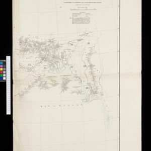
Portion of coal fields tract: Upper Chindwin district
1892
Myanmar
A map surveying coal fields close to the Chindwin River in Upper Burma (Myanmar). Mountains are shown by using hachures: short lines/dashes that give a sense of the shape and steepness of terrain. Survey stations are marked with their height.

Map to accompany preliminary report on the Chin-Lushai Country
1892
Myanmar
Topographical map of the mountainous border region between India and northwest Burma (Myanmar), showing rivers, lakes, villages, towns, roads and railways. High points are marked with their heights so they can be used for triangulation.

Dislocations-Karte der Indo-britischen Streitkräfte in Ost-Indien und der Russischen Streitkräfte in Asien
1892
Myanmar
Four maps showing the locations of British and Russian military units in Asia, including British and Indian (Madras Army) troops in Burma (Myanmar). Extensive legends identify individual regiments, battalions etc.

Stanford's Library Map of Asia
1891
Brunei, Cambodia, East Timor, Indonesia, Laos, Malaysia, Myanmar, Philippines, Singapore, Southeast Asia, Thailand, Vietnam
Southeast Asia is on sheet four of this map. British colonial territory—British Burma, the Straits Settlements, Sarawak, British North Borneo—is highlighted in red, with the Dutch East Indies, Spanish Philippines and Portuguese East Timor also shown.

Kaart van een gedeelte van Borneo: met aanwijzing van de grens tusschen het Nederlandsch gebied en dat van het Britsche Protectoraat
1891
Indonesia, Malaysia, Myanmar
Map marking the border (in orange) agreed between British and Dutch territory on Borneo in 1891. Alternative borders are shown: according to the Dutch (blue), according to the British North Borneo Society (yellow) and proposed by the British (green).

Map to illustrate the operations about Sadon, Upper Burma
1891
Myanmar
Map of northeast Burma (Myanmar) bordering China's Yunnan Province. The title refers to ‘operations’ around the town of Sadon, possibly part of the Burmese resistance movement against British colonial rule in the late 19th century.
- Filter from 1478 to 1900
- English248
- Latin183
- French171
- German76
- Dutch67
- Italian18
- Hindi1
- Portuguese1
- more Language »
- [remove]Myanmar715
- Thailand645
- Malaysia598
- Cambodia594
- Vietnam594
- Laos589
- Indonesia573
- Singapore556
- Brunei525
- Philippines518
- Southeast Asia502
- East Timor466
- more Simple Location »
- Sumatra551
- Borneo506
- Java461
- Malay Peninsula439
- Sulawesi405
- Celebes342
- Siam336
- Western New Guinea291
- Maluku Islands274
- Pegu254
- Sunda Islands214
- Malacca204
- more Detailed Location »


