Search

Search Results

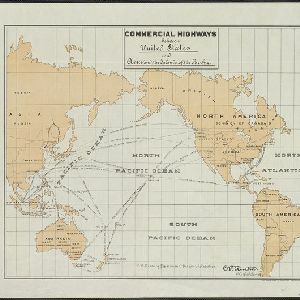
Commercial highways between United States and Asia and the islands of the Pacific

event1900

location_onBrunei, Cambodia, East Timor, Indonesia, Laos, Malaysia, Myanmar, Papua New Guinea, Philippines, Singapore, Southeast Asia, Thailand, Vietnam

The United States Treasury Department produced this map of trade routes crossing the Pacific Ocean between the United States and Asia. Each route is labelled with the names of its ports, and with the distance between them in miles.

The continent and islands of Asia: with all the latest discoveries

event1809

location_onVietnam, Myanmar, Papua New Guinea, Philippines, Singapore, Southeast Asia, Thailand, Malaysia, Laos, Indonesia, East Timor, Cambodia, Brunei

Southeast Asia is on the last sheet of this map of Asia. The South China Sea is labelled ‘Malayan Sea’. Small islands, shoals and reefs are shown. A label in Cochin China (Vietnam) reads ‘mountains inhabited by the uncivilized people called Kemoys’.

close

  • Filter from 1809 to 1900

Current results range from 1809 to 1900