Search

Search Results

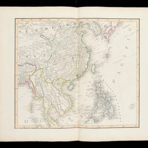
Eastern Islands: Birmah &c.

event1846

location_onBrunei, Cambodia, East Timor, Indonesia, Laos, Malaysia, Myanmar, Philippines, Singapore, Southeast Asia, Thailand, Vietnam

On this map of Southeast Asia, British colonial territory is highlighted within red borders: the Straits Settlements (Singapore, Malacca and Penang) on the west coast of the Malay Peninsula; and British Burma (Chittagong and Aracan, and Tenasserim).

Carte générale de l'Océan Pacifique

event1845

location_onBrunei, Cambodia, East Timor, Indonesia, Laos, Malaysia, Myanmar, Papua New Guinea, Philippines, Singapore, Southeast Asia, Thailand, Vietnam

Marine chart of the Pacific Ocean, including Southeast Asia. Small islands, shoals and reefs are marked, and often named, around the seas and straits of the region.

Asia. Plates 42-45 in Lizars' Edinburgh Geographical General Atlas

eventc.1844-1846

location_onBrunei, Cambodia, Indonesia, Laos, Malaysia, Myanmar, Philippines, Thailand, Vietnam

Southeast Asia is featured on the last of the four sheets of this map of Asia. The South China Sea is particularly detailed, with islands, rocks, shoals and reefs named, sometimes dated, and even marked with the name of the ship that mapped them.

East India Islands

eventc.1844-1846

location_onBrunei, Cambodia, East Timor, Indonesia, Laos, Malaysia, Myanmar, Philippines, Singapore, Southeast Asia, Thailand, Vietnam

From ‘Lizars' Edinburgh Geographical General Atlas’, this mid-19th century map was based on an earlier map by the English cartographer John Cary. It highlights the mountain ranges and rivers of Southeast Asia, and also features many place names.

Ethnographical Map of Asia in the earliest times, illustrative of Dr. Prichard's Natural History of Man

event1843

location_onBrunei, Cambodia, Indonesia, Laos, Malaysia, Myanmar, Philippines, Singapore, Thailand, Vietnam, Southeast Asia

Based on the British ethnologist James Cowles Prichard’s book ‘Natural History of Man’, this map shows the location of ethnicities in Asia. In Southeast Asia, the races are listed as ‘Arakan’, ‘Pegu’, ‘Thay or Siamese’, ‘Anam’ and ‘Pelagian’.

Birman Empire & countries south east of the Ganges

event1831

location_onCambodia, Indonesia, Laos, Malaysia, Myanmar, Thailand, Vietnam

This map of mainland Southeast Asia is divided into colour-coded regions. The Birman Empire (Myanmar) is the most detailed, with internal regions, rivers including the Irrawaddy, mountains and settlements marked.

East India Isles

event1829

location_onBrunei, Cambodia, East Timor, Indonesia, Laos, Malaysia, Myanmar, Vietnam, Thailand, Southeast Asia, Singapore, Philippines

From ‘Thomson’s New General Atlas’, this mid-19th century map was based on an earlier map by the English cartographer John Cary. It highlights the mountain ranges and rivers of Southeast Asia, and also features many place names.

Chart of the East India Islands: exhibiting the several passages between the Indian and Pacific Oceans

event1824

location_onBrunei, Cambodia, East Timor, Indonesia, Malaysia, Philippines, Singapore, Thailand, Vietnam, Southeast Asia, Myanmar

To aid navigation, this map shows small islands, shoals and reefs, maritime routes for use during monsoons or at particular times of the year, bathymetry (sea depth), past explorers’ routes, shipwrecks and text about monsoons, typhoons and currents.

East India Isles

event1817

location_onBrunei, Cambodia, East Timor, Indonesia, Laos, Malaysia, Myanmar, Vietnam, Thailand, Southeast Asia, Singapore, Philippines

This early 19th century map was based on an earlier map by the English cartographer John Cary. It highlights the mountain ranges and rivers of Southeast Asia, and also features many place names of cities, towns and islands.

A new map of the East India Isles

event1801

location_onBrunei, Cambodia, East Timor, Indonesia, Laos, Malaysia, Myanmar, Vietnam, Thailand, Southeast Asia, Singapore, Philippines

An early 19th century map by the English cartographer John Cary, highlighting the mountain ranges and rivers of Southeast Asia. The map also features many place names of cities, towns and islands.

Asia and its islands according to D'Anville

event1799

location_onBrunei, Cambodia, East Timor, Indonesia, Laos, Malaysia, Myanmar, Papua New Guinea, Philippines, Singapore, Southeast Asia, Thailand, Vietnam

This late 18th century map features a number of labels describing the local populations, including the Kemoys ('Savage People') of the mountains of Cokin China (Vietnam), the Biayos of Borneo, and the 'Wild People' of the mountains of Pegu (Myanmar).

The coast of India from Pulo Timon to Pulo Cambir comprehending the Malayan coast, the Gulf of Siam, the coasts of Tsiampa and Cochinchina, with the adjacent islands and part of the isle of Borneo

event1794

location_onThailand, Malaysia, Cambodia, Indonesia, Brunei, Vietnam

Nautical charts like this are detailed around the coasts and on the seas (e.g. river mouths, islands, shoals and reefs) while the interiors are blank. The web of lines is a rhumbline network, while the numbers indicate sea depth (bathymetry).

close

  • Filter from 1630 to 1900

Current results range from 1630 to 1900