Search

Search Results

[Zuid-Chinese Zee]

event1686

location_onIndonesia, Malaysia, Thailand, Cambodia, Vietnam

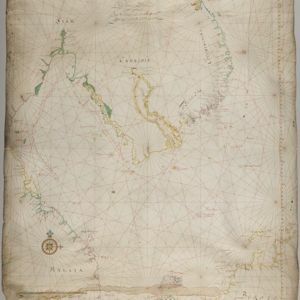
Early navigation map of the South China Sea. The web of lines is a rhumbline network, while the numbers indicate sea depth (bathymetry), both used to aid navigation. A route around the Gulf of Thailand is marked with text and the dates 1643 and 1644.

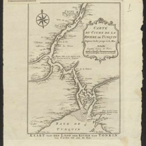
Carte du Cours de la Riviere de Tunquin: depuis Cacho jusqu'à La Mer

event1755

location_onVietnam

Map of the Tunquin River (Red or Hong River) from the city of Cacho (Hanoi, Thailand) to its mouth. At the mouth, bathymetry (sea depth), shoals and anchor points are marked. A place named Hean is labelled as an English and French trading post.

Plan de L'Isle Condor

event1775

location_onVietnam

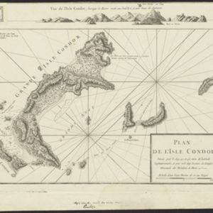
There is a port at the south of this map of the Côn Đảo archipelago (Vietnam), and notes giving details such as a suitable location to careen ships (turning a ship on its side for cleaning or repair). A ruined English fort is also marked.

Kaart van een Gedeelte der Kust van Cochin-China, met de baai en haven van Turon, en het eiland Kal Lao

event1793

location_onVietnam

A map to aid navigation around the Bay of Turon (location of modern city of Da Nang, Vietnam). Bathymetry (sea depth) is marked, as is the route of the Dutch ship ‘Jackaij’ on her departure from the bay. An elevation view of the land is shown below.

Plan of Pulo Condor

event1794

location_onVietnam

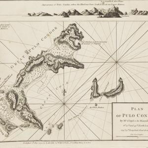
There is a port at the south of this map of the Côn Đảo archipelago (Vietnam), and notes giving details such as a suitable location to careen ships (turning a ship on its side for cleaning or repair). A ruined English fort is also marked.

Map of the River of Don-nai from Cape St. James to the city of Saigon

event1820

location_onVietnam

A map to aid in the navigation of the rivers leading to Saigon (Ho Chi Minh City, Vietnam). Details include bathymetry (water depth), currents, and a side view (or ‘elevation’) of hills to use as a landmark. Tides are described in written remarks.

S.E. Peninsula and Malaysia

event1849

location_onBrunei, Cambodia, East Timor, Indonesia, Laos, Malaysia, Myanmar, Papua New Guinea, Philippines, Singapore, Southeast Asia, Thailand, Vietnam

The colonial possessions of Britain, the Netherlands, Spain, Portugal and Denmark are shown on this mid-19th century map of Southeast Asia. There are inset maps of Penang Island and Singapore, and text describing the region’s colonial history.

Malay Archipelago, or East India Islands

event1851

location_onBrunei, Cambodia, East Timor, Indonesia, Laos, Malaysia, Myanmar, Papua New Guinea, Philippines, Singapore, Southeast Asia, Thailand, Vietnam

This mid-19th century map of Southeast Asia is illustrated with drawings of indigenous people from New Guinea, a ‘bee bear’ (probably a sun bear), a sailboat in front of Victoria Mount in New Guinea, and a village and palm trees in Sarawak, Borneo.

Nederlandsch Oost-Indië

event1865

location_onBrunei, Cambodia, East Timor, Indonesia, Laos, Malaysia, Myanmar, Vietnam, Thailand, Southeast Asia, Singapore, Philippines, Papua New Guinea

This detailed map of the Dutch East Indies in the mid-19th century contains a great deal of information: topographical details, settlements and administrative areas, roads, railways and maritime routes, telegraph lines, inset maps etc.

Übersichtskarte der Französischen Expedition in Hinterindien vom Me-khong bis zum Jang-tse-kiang

event1869

location_onMyanmar, Thailand, Vietnam, Laos

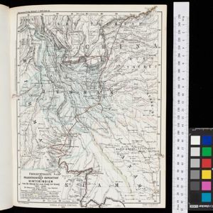
This map of the border region between China, Birma (Myanmar), Siam (Thailand and Laos) and Anam (Vietnam) is marked with the routes of five expeditions of the region from 1837 to 1868. Locations of Roman Catholic missionaries are also shown.

close