
Search Results


Commercial highways between United States and Asia and the islands of the Pacific
1900
Brunei, Cambodia, East Timor, Indonesia, Laos, Malaysia, Myanmar, Papua New Guinea, Philippines, Singapore, Southeast Asia, Thailand, Vietnam
The United States Treasury Department produced this map of trade routes crossing the Pacific Ocean between the United States and Asia. Each route is labelled with the names of its ports, and with the distance between them in miles.

Map of Asia: Printed for the New York Central's 'Four-Track Series'
1900
Malaysia, Indonesia, Thailand, Myanmar, Cambodia, Vietnam, Papua New Guinea, Philippines, Singapore, Brunei, Laos, Southeast Asia
Colonial territory is labelled and colour-coded on this map of Southeast Asia. A list on the left edge gives the colonial status, size and population of Asian countries, and ranks the main cities by population. Gold and iron mines are marked.

Map of the Kingdom of Siam and its dependencies
c.1900
Myanmar, Malaysia, Singapore, Thailand, Laos, Cambodia, Vietnam
The border of the Kingdom of Siam (Thailand) and its internal administrative districts are highlighted in yellow. Inset maps show the cities of Bangkok, Chiengmai (Chiang Mai) and Luang Pra Bang (Luang Prabang) in more detail.
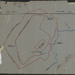
[Outline map of the capital Co-loa, North Vietnam]
1900
Vietnam
This map of the fortified settlement of Cổ Loa (near Hanoi, northern Vietnam) shows the royal city, battlements and gates, a temple and a well. Artefacts dating to the Bronze Age have been found on this early site of Vietnamese civilization.


Stanford's Library Map of Asia
1899
Brunei, Cambodia, East Timor, Indonesia, Laos, Malaysia, Myanmar, Philippines, Singapore, Southeast Asia, Thailand, Vietnam
Southeast Asia is on sheet four of this map. British colonial territory—British Burma, the Straits Settlements, Sarawak, Brunei, British North Borneo—is highlighted in red, with Dutch, Spanish, French and Portuguese territory also shown.

China
1898
Brunei, Cambodia, East Timor, Indonesia, Laos, Malaysia, Myanmar, Philippines, Singapore, Southeast Asia, Thailand, Vietnam
This map highlights the colonisation of Southeast Asia, showing French Indochina (green), British Burma and Malaya (orange), the Dutch East Indies (pink), and the Spanish Philippines (green). In the region, only Siam (yellow) is independent.

Sketch map of China and adjoining regions: showing the density of population, mineral resources, chief products, principal trade routes, existing and projected railways, and inland navigation
1898
Myanmar, Thailand, Vietnam
This map of China features a small part of northeastern Southeast Asia. Population density is shown, along with rivers, trade routes, tidal river navigation limits, railways (existing and suggested), and two coal mines in Tong-King (Vietnam).

Stanford's Map of the Empires of China & Japan with the adjacent parts of the Russian Empire, India, Burma &c.
1896
Myanmar, Vietnam
The most northern part of Southeast Asia is shown on this map of China and Japan, with Burma (Myanmar) and Tong-King (Vietnam) appearing at the bottom of the map. Mountains, rivers and settlements are marked, as well as a railway line in Burma.

Route chart to India and the East
1895
Brunei, Cambodia, East Timor, Indonesia, Laos, Malaysia, Myanmar, Philippines, Singapore, Southeast Asia, Thailand, Vietnam
Map of Asia featuring steamship routes—including around Southeast Asia—connecting ports such as Penang, Singapore, Batavia (Jakarta), Saigon, Bangkok, Rangun (Yangon), Manila, Macassar (Makassar) etc. There is also an inset map of Singapore.
- Filter from 1478 to 1900
- French192
- Latin180
- English179
- Dutch86
- German73
- Italian19
- Spanish2
- Portuguese1
- more Language »
- [remove]Vietnam670
- Cambodia625
- Thailand624
- Malaysia613
- Myanmar594
- Laos593
- Indonesia588
- Singapore574
- Brunei559
- Philippines555
- Southeast Asia519
- East Timor489
- more Simple Location »
- Sumatra553
- Borneo541
- Java485
- Malay Peninsula440
- Sulawesi432
- Celebes359
- Siam321
- Western New Guinea304
- Maluku Islands290
- Pegu233
- Sunda Islands228
- Malacca210
- more Detailed Location »


