
Search Results


Zee- en landkaart waarop de dagelijksche vorderingen eener zeereis van Nederland naar N.O. Indië door een deskundig passagier naauwkeurig aangeteekend
c.1860
Brunei, Cambodia, East Timor, Indonesia, Laos, Malaysia, Myanmar, Philippines, Singapore, Southeast Asia, Thailand, Vietnam
Map of the Eastern Hemisphere featuring a maritime route from the Netherlands to the port of Batavia (Jakarta) in the East Indies, with each day’s progress marked. Other routes around the region and back to Europe via the Suez Canal are also shown.

Schetskaart der afdeeling Westkust van Atjeh
1888
Indonesia
From a Dutch geographical society journal, this map of the west coast of Atjeh (Aceh), Sumatra, shows shoals, reefs, bathymetry (sea depth) and anchor points. On land, there are mountains (with heights), rivers, pepper plantations and rice fields.
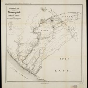
Schetskaart van het stroomgebied der beneden-Ketaun
1888
Indonesia
This map of the lower basin of the Ketaun River features a number of rivers flowing to the sea at the southwest coast of Sumatra. Between the rivers are large areas of forest (‘Zwaar woud’), mountains, villages, roads, hot springs and fields.


