The use of hachures—short lines/dashes that give a sense of the shape and steepness of terrain—highlight the mountain ranges along the west coast of Sumatra, with rivers flowing east. The island is divided into administrative ‘residencies’.
Het eiland Java benevens Bali
event1861
location_onIndonesia
This map shows Java and Bali divided into Dutch colonial administrative areas (‘residencies’), and features mountains, rivers, settlements, and routes. It was designed to be folded within book covers so it could be easily carried.
Het eiland Java benevens Bali
event1861
location_onIndonesia
This map shows Java and Bali divided into Dutch colonial administrative areas (‘residencies’), and features mountains, rivers, settlements, and routes. It was designed to be folded within book covers so it could be easily carried.
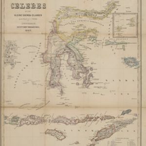
Het Eiland Celebes en de Kleine Soenda-Eilanden
event1862
location_onIndonesia, East Timor
A mid-19th century map of Celebes (Sulawesi) and the Lesser Sunda Islands, divided into colour-coded administrative districts.
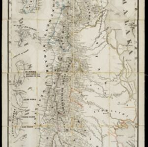
Sumatra
event1868
location_onIndonesia
The use of hachures—short lines/dashes that give a sense of the shape and steepness of terrain—highlight the mountain ranges along the west coast of Sumatra, with rivers flowing east. The island is divided into administrative ‘residencies’.
Java en Madoera
event1873
location_onIndonesia
This detailed late 19th century map shows Java and Madura divided into regencies, and features mountains, roads, railways, and rivers.
Java en Madoera
event1875
location_onIndonesia
This detailed late 19th century map shows Java and Madura divided into regencies, and features mountains, roads, railways, and rivers.
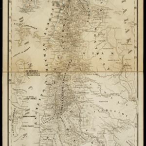
Sumatra
event1879
location_onIndonesia
The use of hachures—short lines/dashes that give a sense of the shape and steepness of terrain—highlight the mountain ranges along the west coast of Sumatra, with rivers flowing east. There is an inset map of the residency of Groot-Atjih (Aceh).
Java
event1890
location_onIndonesia
This detailed late 19th century map shows Java divided into regencies, and features settlements, roads, railways, rivers, and maritime routes. There is also an inset map of the Kangean Islands.
Java
event1890
location_onIndonesia
This detailed late 19th century map shows Java divided into regencies, and features mountains, roads, railways, and rivers. There is also an inset map of the port city of Batavia (Jakarta).
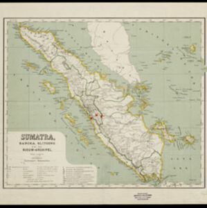
Sumatra, Bangka, Blitoeng en de Riouw-archipel
event1890
location_onIndonesia
This map of Sumatra is divided into administrative areas called ‘residencies’, which include the surrounding islands such as the Riau Archipelago and islands in the South China Sea.
Java
event1894
location_onIndonesia
This detailed late 19th century map shows Java divided into regencies, and features mountains, land and sea routes, and an inset map of the port city of Batavia (Jakarta). It was designed to be folded within book covers so it could be easily carried.