
Search Results


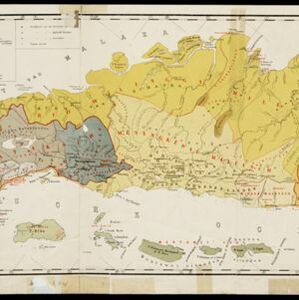
Kaart van zuid Celebes mit uitzondering van het rijk Gowa
1888
Indonesia
Map of the South Peninsula of Celebes (Sulawesi), spread over four sheets. It features crops (alang-alang, coffee, rice, sugarcane), fishing ponds, salt panning, routes, mountains, forests and settlements. The Gowa Regency is left blank.

Topographische kaart der residentie Pasoeroean
1887
Indonesia
The residency of Pasoeroean (Pasuruan), East Java, featuring crops (coffee, cinchona (kina), rice, alang-alang, bamboo) and fishing ponds. Two inset maps: a triangulation map, and a map of distances between settlements by various types of transport.

Topographische kaart der residentie Madoera
c.1885-1887
Indonesia
Three-sheet topographic map of the residency of Madoera (Madura, East Java), with an inset map of distances between locations. Administrative districts, crops—bamboo, sugarcane, alang-alang, rice, coconut, betel—salt pans and fishing ponds are shown.


Kaart van de afdeeling, eiland Saleijer (Silaijara)
1886
Indonesia
Map of Saleijer (Selayar)—an island off the south coast of Celebes (Sulawesi)—and nearby islands. Settlements and roads are shown, including a long road along the west coast which links cities marked with a Dutch flag, illustrating colonial rule.

Kaart van Zuid Celebes met uitzondering van het Rijk Gowa
1886
Indonesia
Map of the South Peninsula of Celebes (Sulawesi), spread over four sheets. It features crops (alang-alang, coffee, rice, sugarcane), fishing ponds, salt panning, routes, mountains, forests and settlements. The Gowa Regency is left blank.

Topographische kaart der residentie Probolinggo
c.1884-1885
Indonesia
Four-sheet topographic map of the residency of Probolinggo (East Java), with an inset map of distances between locations by rail and road, and a signal map. Crops, fishing ponds, sugar factories, and coffee and salt warehouses are shown.

Topographische Kaart der residentie Probolinggo
1885
Indonesia
Four-sheet topographic map of the residency of Probolinggo (East Java), with an inset map of distances between locations by rail and road, and a signal map. Crops, fishing ponds, sugar factories, and coffee and salt warehouses are shown.

Topographische kaart der residentie Soerabaja
1884
Indonesia
The residency of Soerabaja, East Java, featuring crops (coffee, coconut, sugarcane, rice, alang-alang, bamboo) and fishing ponds. Three inset maps: a triangulation map; a map of distances between settlements by types of transport; Bawean Island.

Kaart van een gedeelte van Nieuw-Guinea bevattende het Nederlandsche- en de aangrenzende deelen van het Britsche- en het Duitsche gebied
1884
Indonesia, Papua New Guinea
Map showing the results of an 1884 agreement between the Netherlands and Britain to exchange parts of their colonial territories in New Guinea: the red area was ceded by the Netherlands to Britain; green was ceded by Britain to the Netherlands.


