
Search Results

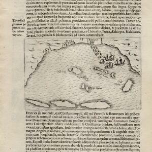
[View of the Bay of Bantam with Houtman's ships]
1614
Indonesia
Two pages from ‘Rerum et urbis Amstelodamensium historia’ by Johannes Pontanus, featuring a drawing of the Dutch merchant seaman Cornelis de Houtman’s ships anchored in the Bay of Bantam (Banten, Java) during the first Dutch expedition to the region.

Le Royaume de Siam avec les Royaumes qui luy sont Tributaires et les Isles de Sumatra, Andemaon etc.
1719
Brunei, Cambodia, Indonesia, Laos, Malaysia, Myanmar, Singapore, Thailand, Vietnam
Map of part of Southeast Asia, featuring a maritime route from the Sunda Strait to the ports of Bantam (Banten) and Batavia (Jakarta) on Java, and then up through the Gulf of Thailand to the Kingdom of Siam. The return route is also marked.

De Straat Sunda in de Oost-Indische Zee tussen de eylanden Sumatra en Iava
1728
Indonesia
Chart of the Sunda Strait, focusing on bays and islands, and showing bathymetry (sea depth), anchor points, shoals and reefs, landmarks, and a rhumbline network, all to aid navigation. Includes an inset map of the bay of the city of Banten on Java.

Deese wassende pas-kaart van Oost-Indien, is nu te bekoomen voor die deselve begeeren
c.1728-1738
Brunei, Cambodia, East Timor, Indonesia, Laos, Malaysia, Myanmar, Papua New Guinea, Philippines, Singapore, Southeast Asia, Thailand, Vietnam
Map of the Indian Ocean dominated by a rhumbline network—a web of interconnected lines used to help plot routes—with a compass rose at the centre. At the top there are (incomplete) drawings of people with text in Dutch, French, English and Spanish.

L'Asie dressée sur les observations de Mrs. de l'Academie Royale de Sciences
1730
Brunei, Cambodia, East Timor, Indonesia, Laos, Malaysia, Myanmar, Philippines, Singapore, Southeast Asia, Thailand, Vietnam
This map features maritime routes: between Siam and Batavia; and five routes of the explorers Juan Gaetan and Olivier du Nord (dated 1542) east of the Philippines. The cartouche has a colourful illustration of Asian people in traditional costume.

De Straat Sunda in de Oost-Indische Zee tussen de Eylanden Sumatra en Java
c.1750
Indonesia
Chart of the Sunda Strait, focusing on bays and islands, and showing bathymetry (sea depth), anchor points, shoals and reefs, landmarks, and a rhumbline network, all to aid navigation. Includes an inset map of the bay of the city of Banten on Java.

Nieuwe kaart van het oostelykste deel der weereld, dienende tot aanwyzing van de scheepstogten der Nederlanderen naar Oostindië
1753
Brunei, Cambodia, East Timor, Indonesia, Laos, Malaysia, Myanmar, Papua New Guinea, Philippines, Singapore, Southeast Asia, Thailand, Vietnam
This map of the Eastern Hemisphere was designed to show maritime routes from the Netherlands to Southeast Asia. It shows New Guinea (‘Nieuw Guinee’) and Australia (‘Nieuw Hollande’) as one landmass, connected via an area labelled ‘Karpentarie’.


