
Search Results

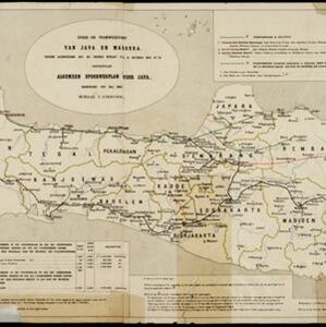
Spoor- en tramwegkaart van Java en Madoera
1894
Indonesia
The railways and tramways of Java and Madoera (Madura) are shown on this late 19th century map, including lines in use, under construction, and being planned. Each line is named, with their route, length, track gauge and construction costs listed.


Straat Riouw: Trigonometrisch opgenomen door het Engelsche opnemings vaartuig
1894
Indonesia
Navigation map of the Riau Strait between Batam, Bintan and Rempang (Riau Archipelago). Bathymetry (sea depth), lighthouses, bouys, currents and obstructions are marked. There are side views of islands and mountains (elevations) to use as landmarks.


Zuidelijk gedeelte van de Chineesche zee: Blad I
1893
Malaysia, Indonesia, Singapore
Navigation map of the southern part of the South China Sea, including the straits of Malacca and Singapore, and the Riau Archipelago. Bathymetry (sea depth), lighthouses, shoals and other obstructions are marked, with hills to use as landmarks.


