
Search Results

Les Isles de la Sonde, Moluques, Philippines, Carolines, et Mariannes
1795
Brunei, Cambodia, East Timor, Indonesia, Laos, Malaysia, Myanmar, Philippines, Singapore, Southeast Asia, Thailand, Vietnam
This map of the Sunda Isles (‘Isles de la Sonde’) (with red borders) and Maluku Islands (‘Isles Moluques’) (green borders) also includes mainland Southeast Asia (blue borders), the Philippines (yellow borders) and New Guinea (green borders).

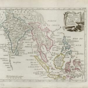
Les Indes orientales et leur archipel
1785
Brunei, Cambodia, East Timor, Indonesia, Laos, Malaysia, Myanmar, Philippines, Singapore, Southeast Asia, Thailand, Vietnam
A piece of paper printed with a list of the various regions of Asia, including the regions of Southeast Asia, has been adhered to the right-hand side of this late 18th century map of Asia.
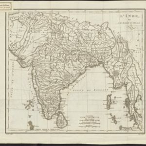
Les Indes orientales et leur archipel: assujetties aux observations astronomiques
1784
Brunei, Cambodia, East Timor, Indonesia, Laos, Malaysia, Myanmar, Philippines, Singapore, Southeast Asia, Thailand, Vietnam
This map of Asia has coloured borders around mainland Southeast Asia, the Philippines, the Sunda Islands (‘Isles de la Sonde’) and the Maluku Islands (‘Isles Moluques’). The cartouche features a drawing of a sailing ship and boxes of goods.

Les Indes orientales et leur archipel: aßujetties aux observations astronomiqes.
1780
Brunei, Cambodia, East Timor, Indonesia, Laos, Malaysia, Myanmar, Philippines, Singapore, Southeast Asia, Thailand, Vietnam
This map of Asia has coloured borders around mainland Southeast Asia, the Philippines, the Sunda Islands (‘Isles de la Sonde’) and the Maluku Islands (‘Isles Moluques’). The cartouche features a drawing of a sailing ship and boxes of goods.

L'Asie divisée en ses Empires et Royaumes
1778
Brunei, Cambodia, East Timor, Indonesia, Laos, Malaysia, Myanmar, Philippines, Singapore, Southeast Asia, Thailand, Vietnam
This map shows the empires and kingdoms of Southeast Asia. Its decorative cartouche features drawings of plants, a camel, a vase, and the heads of children blowing to represent wind. An inset shows tall buildings, possibly Asian temples.

Les Isles de la Sonde, Moluques, Philippines, Carolines, et Mariannes
1778
Brunei, Cambodia, East Timor, Indonesia, Laos, Malaysia, Myanmar, Philippines, Singapore, Southeast Asia, Thailand, Vietnam
This map of the Sunda Isles (‘Isles de la Sonde’) (with red borders) and Maluku Islands (‘Isles Moluques’) (blue borders) also includes mainland Southeast Asia (green borders), the Philippines (yellow borders) and New Guinea (green borders).
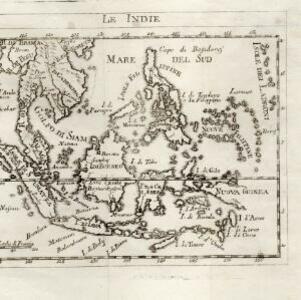
Le Indie
1778
Brunei, Cambodia, East Timor, Indonesia, Laos, Malaysia, Myanmar, Philippines, Singapore, Southeast Asia, Thailand, Vietnam
This late 18th century map of Southeast Asia is by the Dutch cartographer Henri Abraham Chatelain (1648–1743). As often found on maps of this time, larger settlements are represented by drawings of small groups of buildings.
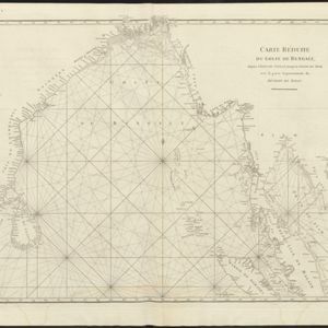
Carte réduite du Golfe de Bengale, depuis l'isle de Ceylan jusqu'au Golfe de Siam, avec la partie septentrionale du détroit de Malac
1775
Myanmar, Thailand, Cambodia, Malaysia, Indonesia
Map of the Bay of Bengal, with the western coast of mainland Southeast Asia. Shoals, reefs and islands are marked. The web of lines is a rhumbline network, while the numbers indicate sea depth (bathymetry), both used to aid navigation.


