
Search Results


Carte particuliere des isles Moluques
1750
Indonesia
A map of a small island chain off the west coast of the island of Gilolo (modern Halmahera in the Maluku Islands of Indonesia). The military forts on the islands were used by the European colonial powers during conflicts over the area’s spice trade.
Les Isles de la Sonde
1749
Brunei, Indonesia, Malaysia, Singapore
This colourful mid-18th century map of the Sunda Isles (‘Isles de la Sonde’) includes the Malay Peninsula in addition to Sumatra, Java and Borneo. Mountain ranges and jungles are shown pictorially, and the islands and coasts feature shoals and reefs.

Isles Philippines et Moluques
1749
Indonesia, Philippines, Papua New Guinea, East Timor
From the second edition (1749) of ‘Atlas Portatif Universel et Militaire’ by the French cartographer Gilles Robert de Vaugondy (1688–1766), this map features the Philippines (in blue) and Maluku Islands (in red).


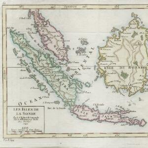
Isles de la Sonde
1748
Brunei, Indonesia, Malaysia, Singapore
Three of the larger Sunda Islands—Sumatra, Java and Borneo—are shown on this mid-18th century map, along with a few of the smaller islands such as Bali, Lombok and Sumbawa. Celebes (Sulawesi) and some of the other smaller islands are not included.

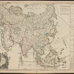
L'Asie suivant les dernres. observons. des Moscovites
1747
Brunei, Cambodia, East Timor, Indonesia, Laos, Malaysia, Myanmar, Philippines, Singapore, Southeast Asia, Thailand, Vietnam
The title of this mid-18th century map translates as ‘Asia following the latest observations of the Muscovites/Russians’. Written notes in French list the regions, islands, empires, kingdoms, colonial possessions, religions and languages of Asia.


Suite de l'Ocean Oriental contenant les Isles de la Sonde, les costes de Tunquin et de la Chine, les isles du Japon, les Philippines, Moluques
1746
Brunei, Cambodia, East Timor, Indonesia, Malaysia, Papua New Guinea, Philippines, Singapore, Thailand, Vietnam, Southeast Asia
The coast of New Guinea (‘Nouvelle Guinée’) is represented in part by a dotted line on this mid-18th century map, indicating that the exact coastlines were unknown at this time. The western tip is labelled ‘C. de Bonne Esperance [Cape of Good Hope]’.


