
Search Results


Oostkust: Aroe-Eilanden / Ankerplaats voor Watoelei en Koemoel
1896
Indonesia
Map of the east coast of the Aru Islands (Maluku Islands), with bathymetry (sea depth), tides and currents, shoals and other obstructions. An inset map shows the anchorage at islands off the coast, along with elevation views of the islands.

Ankerplaatsen en mondingen van rivieren op de Noord- en Oostkust van Sumatra: Blad I
1896
Indonesia
Eleven separate maps of bays and river mouths of Sumatra, including two bays on the island on Bras (Breueh Island), and the bay at Kota Radja (Banda Aceh). Bathymetry (sea depth), anchor points, reefs and shoals are marked, along with tide data.

Vaarwaters en ankerplaatsen op de oostkust der Aroe-eilanden
1896
Indonesia
Four navigation maps of the waterways and anchorages around the east coast of the Aru Islands (in the Maluku Islands, near New Guinea). Bathymetry (sea depth), shoals and other obstructions are shown, with trees and villages to use as landmarks.

Vaarwaters en ankerplaatsen op de Zuidkust van Celebes
1896
Indonesia
Eight navigation maps from around the south coast of Celebes (Sulawesi). Anchorages, roadsteads (bodies of water sheltered from tides/currents), bathymetry (sea depth), shoals and other obstructions are shown, with hills and settlements as landmarks.

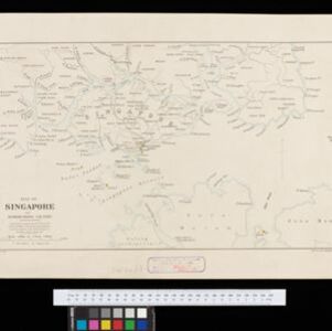
Map of Singapore and surrounding country
1896
Singapore, Malaysia, Indonesia
Map of Singapore Island, including the surrounding islands and straits, and southern Johor. Lighthouses are marked in red and yellow, including Horsburgh Lighthouse on Pedra Branca, Raffles Lighthouse and Fort Canning Lighthouse.


Kaiser Wilhelms-Land: Das Hinterland der Astrolabe-Bucht bis zum Ramu-Fluss
1896
Papua New Guinea
Map of part of the north coast of Kaiser-Wilhelmsland (German New Guinea) spread over two sheets. It focuses on rivers, noting width, depth, temperature, currents, vegetation etc.; and on mountains, showing heights and side views (elevations).

Route chart to India and the East
1895
Brunei, Cambodia, East Timor, Indonesia, Laos, Malaysia, Myanmar, Philippines, Singapore, Southeast Asia, Thailand, Vietnam
Map of Asia featuring steamship routes—including around Southeast Asia—connecting ports such as Penang, Singapore, Batavia (Jakarta), Saigon, Bangkok, Rangun (Yangon), Manila, Macassar (Makassar) etc. There is also an inset map of Singapore.


Moluksche archipel: Baai van Amboina
1895
Indonesia
A map to aid navigation in Ambon Bay, on the island of Ambon in the Maluku Islands: bathymetry (sea depth) and mountains are shown along the coasts, with inset maps of a coal mine pier and Fort Victoria. A second map updates the coal mine pier map.
- Filter from 1565 to 1900
- Dutch267
- English201
- French193
- Latin132
- German49
- Italian20
- Spanish5
- Portuguese1
- more Language »
- Indonesia697
- Malaysia467
- Singapore406
- Thailand390
- Vietnam383
- Brunei377
- Cambodia377
- Philippines367
- Myanmar354
- Laos333
- East Timor326
- Southeast Asia305
- more Simple Location »
- Port110
- Pier34
- Railway Station5
- River549
- Road119
- Path45
- Telegraph/Telephone23
- Postal Route22
- Railway/Tramway19
- Canal18
- Bridge13


