
Search Results


Sketch map shewing the rivers and an outline of the coast... Gulf of Papua, British New Guinea
1893
Papua New Guinea
Map of part of the east coast of the Gulf of Papua, with river mouths, shoals, bathymetry (water depth). On land, notes on terrain (‘Hills 100 to 150 ft. high’), land (‘Good soil’), vegetation (‘Nipa and Sago Palms’) and people (‘Ipikoi Tribe’).

Sumatra Oostkust: Monden der Koealoe en Panei rivieren
1892
Indonesia
Navigation map of the mouths of the Koealoe (Kualu) and Panei (Barumun and Bila) rivers on the east coast of Sumatra. Large sand and mud banks, bathymetry (sea depth), bouys and currents are marked. On land, tall trees are shown to use as landmarks.

New sketch map of the protected Malay State of Perak
1892
Malaysia
Map of state of Perak (Malay Peninsula) with a table of statistics: area, population, road/railway/river lengths, revenue, tin exports. Straits Settlements highlighted red. Someone has added handwritten travel times/distances by steamer/road/train.

Schutzgebiet der Neu-Guinea-Kompanie
c.1892-1893
Indonesia, Papua New Guinea
Very detailed six-sheet map of eastern New Guinea, with numerous inset maps of bays and islands, and other inset maps covering ethnography, explorers of the region, marine routes across the Pacific Ocean, cannibalism, missionaries activity etc.

Map of part of Moratau (Fergusson Island) and Duau (Normanby Island): British New Guinea
1891
Papua New Guinea
Map of parts of Fergusson and Normanby islands (east coast of New Guinea). Bathymetry (sea depth), reefs and shoals are marked, along with landmarks (mountains, villages, trees). Territories of two indigenous tribes—the Subia and Manayaya—are shown.

Kaart der Bataklanden en van het eiland Nijas
1890
Indonesia
A large-scale map of northern Sumatra, spread over 16 sheets, and divided into administrative regions. The island of Nijas (Nias) is marked with the locations of local tribes, and there is a list of other maps referenced in producing the map.

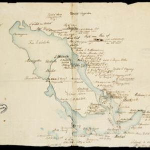
Rough Sketch of 200 miles of the western portion of British New Guinea, including rivers
1890
Papua New Guinea
Map of British New Guinea with notes on the terrain (‘Low country’), vegetation (‘Mangrove, Nipa and Fan Palms’), crops (‘Small plantations Sugar cane & Taro’), coastal features (‘Coral and Sand flats) and people (‘Friendly tribe’, ‘Dariamo Tribe’).

Map of the Fly River, British New Guinea, as traversed by Sir William MacGregor and party
1890
Papua New Guinea
Three maps on one sheet of the Fly River in British New Guinea, from the mouth to where it meets the Palmer River. Bathymetry (water depth) and sandbanks are marked at the mouth and landmarks—hills, vegetation, villages—are noted along the length.


