Search

Search Results

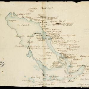
Map of part of Moratau (Fergusson Island) and Duau (Normanby Island): British New Guinea

event1891

location_onPapua New Guinea

Map of parts of Fergusson and Normanby islands (east coast of New Guinea). Bathymetry (sea depth), reefs and shoals are marked, along with landmarks (mountains, villages, trees). Territories of two indigenous tribes—the Subia and Manayaya—are shown.

Kaiser Wilhelms Land, Bismarck Archipel und Salomon Inseln

event1891

location_onPapua New Guinea

Navigation map of Kaiser-Wilhelmsland, in German New Guinea. It features bathymetry (sea depth), reefs and shoals, lighthouses (coloured red and yellow) and landmark mountains. A boundary divides German and British colonial territories on New Guinea.

Kaart van den Nederlandsch-Indischen Archipel

event1890

location_onIndonesia, East Timor, Brunei, Cambodia, Malaysia, Philippines, Singapore, Southeast Asia, Thailand, Vietnam

The seas of the Dutch East Indies are the focus of this map, with maritime routes, sea temperature, sea depth, currents and monsoons shown. There are graphs of population by ethnicity, agriculture and livestock, trade and shipping, and trade exports.

Java

event1890

location_onIndonesia

This detailed late 19th century map shows Java divided into regencies, and features settlements, roads, railways, rivers, and maritime routes. There is also an inset map of the Kangean Islands.

[Toba meer]

event1890

location_onIndonesia

A hand-drawn map of Lake Toba, northern Sumatra, marked with the route of an eight-day journey around the southern lake area—both on land and by boat—starting and ending in the town of Baligé.

Kaart der Bataklanden en van het eiland Nijas

event1890

location_onIndonesia

A large-scale map of northern Sumatra, spread over 16 sheets, and divided into administrative regions. The island of Nijas (Nias) is marked with the locations of local tribes, and there is a list of other maps referenced in producing the map.

Rough Sketch of 200 miles of the western portion of British New Guinea, including rivers

event1890

location_onPapua New Guinea

Map of British New Guinea with notes on the terrain (‘Low country’), vegetation (‘Mangrove, Nipa and Fan Palms’), crops (‘Small plantations Sugar cane & Taro’), coastal features (‘Coral and Sand flats) and people (‘Friendly tribe’, ‘Dariamo Tribe’).

Map of the Fly River, British New Guinea, as traversed by Sir William MacGregor and party

event1890

location_onPapua New Guinea

Three maps on one sheet of the Fly River in British New Guinea, from the mouth to where it meets the Palmer River. Bathymetry (water depth) and sandbanks are marked at the mouth and landmarks—hills, vegetation, villages—are noted along the length.

Océan Indien

event1889

location_onBrunei, Cambodia, East Timor, Indonesia, Laos, Malaysia, Myanmar, Philippines, Singapore, Southeast Asia, Thailand, Vietnam

A nautical chart of the Indian Ocean showing bathymetry (sea depth), including in great detail around the seas and straits of Southeast Asia.

Sketch Map of Mai Cussa or Baxter River, and Wasu Cussa or Chester River, with their tributaries

event1888

location_onPapua New Guinea

Map of an expedition along two rivers on the southern coast of British New Guinea, with notes of terrain (‘Undulating country’), vegetation (‘Coconut Palms’) and wildlife (‘Flying Foxes’). More details have been added by hand (‘Ridge about 10ft.’).

Kaart der Karimon-Djawa eilanden

event1887

location_onIndonesia

Map of the Karimunjawa Islands (Java Sea) marked with the locations of shoals, reefs, anchor points and sea depth (bathymetry) to aid navigation; and with geological sites (recent rock/coral formation, basalt rock, schist rock and quartz).

close