
Search Results
233 Results found


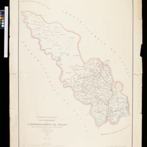
Plan topographique de l'arrondissement de Saigon
1885
Vietnam
Map of the district of Saigon (Ho Chi Minh City, Vietnam), based around the Fleuve Soirap (Soài Rạp River) as it winds its way down to the South China Sea. The city of Saigon is on its banks, surrounded by more rivers, roads, fields and villages.

Kaart van het terrein des oorlogs in Groot-Atjeh
1883
Indonesia
The Aceh War (1873–1904) between the Sultanate of Aceh and Dutch colonists is highlighted on this map of Groot-Atjeh in 1876. Flag symbols mark the locations of Dutch military posts, and some villages are described as ‘verbrande [burnt]’.

Kaart van het terrein des oorlogs in Groot-Atjeh in 1876
1883
Indonesia
The Aceh War (1873–1904) between the Sultanate of Aceh and Dutch colonists is highlighted on this map of Groot-Atjeh in 1876. Flag symbols mark the locations of Dutch troops, while a red line records the route marched by ‘agitating troops’ in 1875-6.

Kaart van het terrein des Oorlogs in Groot-Atjeh in 1876
1883
Indonesia
The Aceh War (1873–1904) between the Sultanate of Aceh and Dutch colonists is highlighted on this map of Groot-Atjeh in 1876. Flag symbols mark the locations of Dutch troops, while a red line records the route marched by ‘agitating troops’ in 1875-6.

Itinéraire de Hanoi à That-khe par Lang-son (Frontière Chinoise du Kouang-Si)
1881
Vietnam
A late 19th century map depicting a route from Hanoi to That-Khe via Lang-Son (in northern Vietnam, near the border with China at Kouang-Si (Guangxi)). Two inset maps feature plans of military forts, villages, rivers and fields along the route.

Plan topographique de l'arrondissement de Bien-Hoa
1881
Vietnam
Two-sheet map of the district of Bien-Hoa (Biên Hòa) east of Ho Chi Minh City, Vietnam. The area is dominated by rivers, wetlands and mangroves. Labels describe the terrain e.g. ‘Bois marécageux avec rivières [Swampy woods with rivers]’.

[Schetskaarten van versterkingen, loopgraven, stellingen, bentengs e.d. uit de Atjeh oorlog]
1880
Indonesia
Multiple maps from the Aceh War, spread over 12 sheets. Includes maps of fortifications, trenches, battle formations; building plans, including the Aceh Sultan’s palace; topographic maps; and drawings of a ‘kotta mara’ (fortified raft).

Tocht van de expeditie kolonne over Seglie naar Telok Kadjoe van 6-24 Mei 1878
1879
Indonesia
Map of a Dutch military expedition from Seglie (Sigli) on the northeast coast of Sumatra to Telok Kadjoe, during the Aceh War between Aceh and Dutch colonists. They land at Sigli and cross marshland, high grass, and rice and sugarcane fields.

Algemeene kaart van Nederlandsch Indië
1879
Cambodia, Indonesia, Papua New Guinea, East Timor, Southeast Asia, Thailand, Malaysia, Philippines, Laos, Vietnam, Singapore, Brunei, Myanmar
A late 19th century map of the Dutch East Indies on four sheets, detailing maritime routes around the region. There are also inset maps showing railways, rivers, roads, and telegraph systems, as well as individual islands and cities.
- Filter from 1547 to 1900
- [remove]Military Fort233
- Kampong/Village97
- Residential Area89
- Church67
- Cemetery/Columbarium54
- Hospital54
- Military Barracks52
- Public Space49
- Temple44
- Palace32
- Post Office27
- Mosque21
- Jail/Prison18
- Well17
- more Settlement Features »


