
Search Results

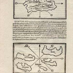
[Java Minor and map of Necumera, Locaz, Patera, Botegon, Mangama]
1547
Thailand, Indonesia
Taken from Benedetto Bordone's ‘Isolario [The Book of Islands]’, these pages contain two maps: one of Sumatra (‘Iaua Minore’), and one of a group of five unknown islands (Locaz is thought to possibly be Thailand).
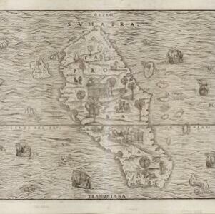


Sumatra ein grosse Insel: so von den alten Geographen Taprobana genennet worden
c.1588-1628
Indonesia, Malaysia, Singapore, Thailand
A map of Sumatra featuring villages, mountains and rivers; text describing the island; and a drawing of a man riding an elephant. The title uses the name ‘Taprobana’ for Sumatra, stating it was a name used by ‘ancient geographers [alten geographen]’.


Amboina ad viumu descripta quo tempore Admiarallus Wibrandus Warwicensis cum quatuor nauibus ante eam in achoris staret a 1599 mese martio
1614
Indonesia
The Latin title of this map refers to an Admiral Wibrand of Warwick, who visited the island of Amboina (Ambon Island in the Maluku Islands) in March 1599.

[View of the island of Ternate with the town Gamme Lamme]
1614
Indonesia
Two drawings and text from ‘Rerum et urbis Amstelodamensium historia’ by Johannes Pontanus: the port and town of Gamme Lamme on the island of Ternate, with local and European vessels; and a naval battle between Dutch and Portuguese ships.


[Map of the East Indies]
1666
Vietnam, Myanmar, Papua New Guinea, Philippines, Singapore, Southeast Asia, Thailand, Malaysia, Laos, Indonesia, East Timor, Cambodia, Brunei
This mid-17th century map of Southeast Asia has a maritime focus, with shoals and reefs, and the coastal areas marked in great detail, while the interiors remain mostly blank. The Great Wall of China can be seen at the top of the map.


