Search

Search Results

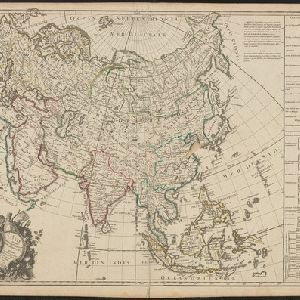
Belgii pars septentrionalis communi nomine vulgo Hollandia nuncupata continens statum potentissimae Batavorum Reipublicae septimas seu Provincias Foederatas

event1700

location_onBrunei, Cambodia, East Timor, Indonesia, Laos, Malaysia, Myanmar, Philippines, Singapore, Southeast Asia, Thailand, Vietnam

An 18th century map of the Netherlands, with an inset map of Southeast Asia highlighting the trade of the Dutch and their colonies. Within the inset is a drawing of the port of Batavia (Jakarta) with sailing ships in the harbour and mountains behind.

L'Asie suivant les dernres. observons. des Moscovites

event1747

location_onBrunei, Cambodia, East Timor, Indonesia, Laos, Malaysia, Myanmar, Philippines, Singapore, Southeast Asia, Thailand, Vietnam

The title of this mid-18th century map translates as ‘Asia following the latest observations of the Muscovites/Russians’. Written notes in French list the regions, islands, empires, kingdoms, colonial possessions, religions and languages of Asia.

Asie divisée en ses principaux Etats, Empires & Royaumes

event1791

location_onBrunei, Cambodia, East Timor, Indonesia, Laos, Malaysia, Myanmar, Philippines, Singapore, Southeast Asia, Thailand, Vietnam

A late 18th century map of Asia, with notes on the principal states, empires and kingdoms of Asia written in French on the right-hand side.

Asien am Ausgange des XVIIten Jahrhunderts

eventc.1800-1899

location_onBrunei, Cambodia, East Timor, Indonesia, Laos, Malaysia, Myanmar, Philippines, Singapore, Southeast Asia, Thailand, Vietnam

This map of Asia, from an atlas by the German cartographer Karl von Spruner, is colour-coded to show the colonial possessions of the European powers—Netherlands, Portugal, Spain, France, Britain and Denmark—at the end of the 17th century.

Asien gegen Ende des XVIIIten Jahrhunderts

eventc.1800-1899

location_onBrunei, Cambodia, East Timor, Indonesia, Laos, Malaysia, Myanmar, Philippines, Singapore, Southeast Asia, Thailand, Vietnam

This map of Asia, from an atlas by the German cartographer Karl von Spruner, is colour-coded to show the possessions of the Indian Maratha Empire, and of the European colonial powers at the end of the 18th century.

A New general map of the East Indies, exhibiting in the Peninsula on this side of the Ganges or Hindoostan, the several partitions of the Mogul's Empire

event1823

location_onMalaysia, Brunei, Indonesia, Cambodia, Thailand, Vietnam, Myanmar, Laos, Southeast Asia

This 19th century map highlights British colonial possessions in India (in red), and the various kingdoms of northern Southeast Asia, including the Birman Empire (Myanmar), Cochin China and Tonkin (Vietnam), Lao (Laos), Siam (Thailand), and Cambodia.

Hinterindien

event1832

location_onIndonesia, Malaysia, Singapore, Cambodia, Vietnam, Thailand, Myanmar, Laos

A mid-19th century German map of mainland Southeast Asia showing a mixture of ancient kingdoms (e.g. Birma, Siam, Anam) and the colonial possessions of Britain (Malaya, Straits Settlements) and Denmark (Nicobar Islands).

Map of the Burman Empire including also Siam, Cochin-China, Ton-king and Malaya

event1832

location_onVietnam, Myanmar, Malaysia, Indonesia, Thailand, Laos, Cambodia, Brunei, Singapore

Regional borders are colour-coded on this mid-19th century map of mainland Southeast Asia, with British colonial territory in red (including part of the Burman Empire, the Straits Settlements, and Sarawak on Borneo).

Reduzirte Karte vom Sunda- oder Borneo-Meere

event1835

location_onIndonesia, Malaysia

A navigation map of the Java Sea and Sunda Islands, with bathymetry (sea depth), maritime routes, shoals and reefs, and elevations (side views of terrestrial landmarks). Inset maps feature the bay at Batavia and the straits between the Sunda Islands.

Karte von der Insel Sumatra

event1837

location_onSingapore, Indonesia, Malaysia

Based on surveys by Sir Stamford Raffles, this German map of Sumatra focuses on the navigation of coasts and straits, with bathymetry (sea depth), anchor points, shoals and reefs marked, including on inset maps of Singapore and the Bangka Strait.

Hindoustan et Indo-Chine

event1840

location_onCambodia, Laos, Malaysia, Myanmar, Singapore, Thailand, Vietnam

Mainland Southeast Asia is labelled ‘Indo-Chine’ on this mid-19th century map, with ancient kingdoms (e.g. Empire Birman) and colonial possessions (e.g. Straits Settlements) highlighted with colour. Major mountain chains and rivers are also named.

Map of India: shewing the British possessions in the year 1842

event1842

location_onIndonesia, Singapore, Thailand, Cambodia, Myanmar, Malaysia

A mid-19th century map colour-coded with British, French, Portuguese, Danish and Dutch colonial possessions in India and western Southeast Asia, as well as the ‘Native States’. A table lists the dates when the British acquired each area.

close

  • Filter from 1700 to 1900

Current results range from 1700 to 1900