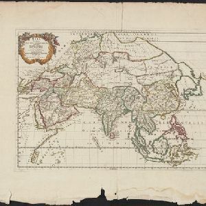
Search

Search Results

Asia Vetus

event1667

location_onBrunei, Cambodia, East Timor, Indonesia, Laos, Malaysia, Myanmar, Philippines, Singapore, Southeast Asia, Thailand, Vietnam

This 17th century map by the French cartographer Nicolas Sanson shows Southeast Asia in the context of the rest of the Asian continent, and even includes parts of Africa and Europe. The decorative cartouche features winged cherubim.

Isole dell'Indie divise in Filippine, Molucche e della Sonda

event1680

location_onBrunei, Cambodia, East Timor, Indonesia, Malaysia, Laos, Myanmar, Philippines, Singapore, Southeast Asia, Thailand, Vietnam

Dotted lines and colours divide maritime Southeast Asia into three regions on this map: the Philippine archipelago, Maluku Islands and Sunda Islands. The cartouche features cherub mermaids, and a map of mainland Southeast Asia is on the reverse.

Isole dell'India, cioè le Molucche, le Filippine e della Sonda: parte de Paesi di nuoua scoperta e l'Isole de Ladri nel Mare del Zud

event1683

location_onBrunei, Cambodia, East Timor, Indonesia, Laos, Malaysia, Myanmar, Papua New Guinea, Philippines, Singapore, Southeast Asia, Thailand, Vietnam

Dotted lines on this late 17th century map demarcate regions and kingdoms (which also have a crown symbol). The cartouche is shaped like a giant shell supported by mermen, with cherubs holding up shells and pearls on top.

Isole dell'Indie divise in Filippine, Molucche e della Sonda

eventc.1691-1696

location_onBrunei, Cambodia, East Timor, Indonesia, Laos, Malaysia, Myanmar, Philippines, Singapore, Southeast Asia, Thailand, Vietnam

Dotted lines and colours divide maritime Southeast Asia into three regions on this map: the Philippine archipelago, Maluku Islands and Sunda Islands. The cartouche features cherub mermaids carrying a banner and shield.

Partie de la nouvelle Grande Cartes des Indes Orientales, contenant les Isles Maldives, Ceylan, Malacca, Sumatra &c.

event1700

location_onIndonesia, Malaysia, Singapore, Thailand

Sumatra and the Malay Peninsula feature on this map of the Indian Ocean. Enganno Island, west of southern Sumatra, has a label that translates as ‘inhabited by very pernicious savages’. An inset map depicts the Madura Strait between Java and Madura.

Karte von Hoch-Asien: zu C. Ritter's Erdkunde, Buch II, Asien

event1833

location_onMyanmar

Four-sheet map of Asia from Carl Ritter’s book ‘Erdkunde [Geography]’, including the northwest Birman Empire (Myanmar) and featuring rivers, mountains, administrative districts and settlements. Plus a page of elevations of Asian mountain ranges.

Eastern islands or Malay archipelago

event1836

location_onBrunei, Cambodia, East Timor, Indonesia, Laos, Malaysia, Myanmar, Philippines, Singapore, Southeast Asia, Vietnam, Thailand

Brief notes printed on this 19th century map of Southeast Asia provide details about each region, including: numbers and ethnicity of the population, local or colonial rulers, crops and products, geography (corals, forests, volcanos, earthquakes).

Nederlandsch Oost-Indië

event1840

location_onBrunei, East Timor, Indonesia, Malaysia, Papua New Guinea, Philippines, Singapore

The Dutch East Indies are bordered in red on this mid-19th century map. A maritime postal route from China to Europe, via Singapore and Penang, is shown. Another maritime route, from Batavia to Singapore, is also marked.

Nederlandsch Oost-Indië

event1865

location_onBrunei, Cambodia, East Timor, Indonesia, Laos, Malaysia, Myanmar, Vietnam, Thailand, Southeast Asia, Singapore, Philippines, Papua New Guinea

This detailed map of the Dutch East Indies in the mid-19th century contains a great deal of information: topographical details, settlements and administrative areas, roads, railways and maritime routes, telegraph lines, inset maps etc.

The central part of British Burmah with the Shan provinces of Burmah and Siam

event1870

location_onMyanmar, Thailand

The routes of eight expeditions through Burma (Myanmar) and Siam (Thailand) are shown, with text noting ‘Ancient ruins with sarcophagi, mummies’, ‘bazaar… great variety of European goods’, ‘great thoroughfare for the Chinese trading with the Shans’.

Eastern British frontier bordering on Burmah and Munneepoor

event1871

location_onMyanmar

This map shows the border between the British Empire (modern Bangladesh) and Burmah (Myanmar). Although the Burmah part of the map is mostly blank, there is a reference to ‘Shendoos’ (now known as the Lai people).

close