Search

Search Results

Kaart van Timor en omliggende eilanden

event1898

location_onIndonesia, East Timor

On this map of the island of Timor, the Dutch and Portuguese colonial territories are divided by orange borders. The Dutch territory—most of the western half of the island—is divided by green borders into administrative districts.

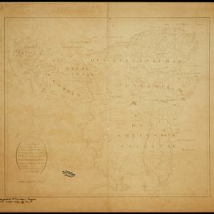
Caart eeniger ryken gelegen op het eyland Groot Java bestaande in het Koningryk Jaccatra de regentschappen Tjanjoer, Bandong, Timbanganten en Batoelejan als mede een gedeelte van Parrakkanmoentjang en Crawang

event1898

location_onIndonesia

A hand-drawn late 19th century map of western Java, divided into regencies. The map is orientated with south at the top so that Batavia, on the northern coast of Java, is at the bottom of the map.

Overzichtskaart van Groot-Atjeh en aangrenzende kuststaten

event1898

location_onIndonesia

Map of Groot-Atjeh (Aceh, Sumatra), focusing on the area around the capital Kota Radja (Banda Aceh) and along the coasts. There is a list of telephone connections in the area, and an inset map of the region divided into administrative districts.

Kaart van de Kleine Soenda eilanden

event1898

location_onIndonesia

The Lesser Sunda Islands are shown spread over these three late 19th century maps. Each island is divided into local administrative districts, with cities, mountains and routes marked. Shoals, lighthouses and anchor points are shown at the coasts.

Schetskaart van het Toba-meer en aangrenzende landstreken

event1898

location_onIndonesia

Map of Lake Toba and the surrounding area in northern Sumatra, featuring mountains, forests, types of terrain (undergrowth, field, grass), rivers, roads and settlements. There is an inset map that shows the other maps referenced in producing the map.

Noord-Celebes

event1898

location_onIndonesia

A late 19th century map of the Minahasa Peninsula, northern Celebes (Sulawesi), marked with the locations of mines (‘mÿnen’). The red borders indicate areas for ‘mijnbouwkundig onderzoek [mining research]’.

Kaart de residentie Wester-afdeeling van Borneo

event1898

location_onIndonesia

Topographical map of western Borneo, with inset maps of the islands off the west coast, and of the city of Pontianak including the docks and crops grown near the city (rice, coconut, mangosteen, sago, alang-alang, indigo plant, sugarcane, bamboo).

Landbouw-ondernemingen in de afdeelingen Deli, Batoe Bahara en Asahan (Residentie Oostkust van Sumatra)

event1898

location_onIndonesia

On this map of the east coast of northern Sumatra, red borders divide the land into agricultural properties, each with a number to identify it. The whole area is divided into colour-coded administrative districts.

Overzichtskaart van de bosschen en van de indeeling der Boschdistricten op Java en Madoera

event1898

location_onIndonesia

Different types of forest are shown on this late 18th century map of Java and Madura, with the land divided into 21 forest districts. Roads, railways and major settlements are also marked.

Spoor- en tramwegkaart van Java en Madoera

event1898

location_onIndonesia

The railways and tramways of Java and Madoera (Madura) are shown over two sheets of this late 19th century map, including lines in use, under construction, and being planned. An inset map shows details of a line near Batavia (Jakarta).

Figuratieve schetskaart van de Pedirstreek

event1898

location_onIndonesia

Map of Pedirstreek (Pidie Regency) on the east coast of Aceh, Sumatra, spread over two sheets. It is divided into administrative areas, and features rice paddies, villages, mosques, roads and local fortifications.

Kaart van 't Rijk Djambi

event1898

location_onIndonesia

Hand-drawn map of the Batang Hari River and its tributaries flowing through west from the city of Djambi (Jambi) to the Barisan Mountains. Types of terrain are noted along the route, e.g. ‘laag heuvelachtig boschterrein [low hilly forest terrain]’.

close