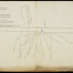
Search

Search Results

Topographische kaart van het eiland Biliton

event1894

location_onIndonesia

This map of the island of Billiton (Belitung, Indonesia) features mountains, rivers, railways, roads, settlements, coconut plantations and administrative borders. An inset map shows the island’s port and capital city Tanjung Pandan.

Koninginne baai met Emma haven

event1894

location_onIndonesia

Map of Koninginne Baai (Bayur Bay, west coast of Sumatra) used to navigate Emma Haven (now Port of Teluk Bayur). It features bathymetry (sea depth), reefs and shoals, as well as lighthouses, buoys and two elevations (side views) of coastal mountains.

Emplacement Belawan 1888 / Emplacement Belawan 1890: Zuidelijke Uitbreiding

event1891

location_onIndonesia

Two plans of an emplacement (railway yard) at Belawan Port in Medan, North Sumatra, showing it in 1888 and again in 1890 after it had been extended with new railway track, buildings and docks.

[Verzamelkaart van door uitbarsting en vloedgolf verwoeste gebieden]

event1883

location_onIndonesia

Nine maps of the effects of the 1883 Krakatoa volcanic eruption, including on Rakata Island itself, and Calmeyer Island (formed by the eruption). Other maps use brown shading to show the flooding of nearby islands and settlements by ensuing tsunamis.

Bataviasche havenwerken

event1880

location_onIndonesia

A map of the rail, canal and road connections of Batavia (Jakarta, Java) and its port of Tanjung Priok. There is an inset map of the port—harbours, dock, coal sheds, well and water tower—and cross-sections of the inner harbour walls and harbour dam.

Fort Nieuw Victoria

event1880

location_onIndonesia

Two plans of Fort New Victoria in Ambon, Maluku Islands. There is a pier at the front of the fort which projects into Ambon Bay. In the second plan, the fort has seven bastions and a moat at the rear.

Topographische kaart der residentie Cheribon

event1877

location_onIndonesia

Six-sheet topographic map of the residency of Cheribon (Cirebon, West Java), with an inset of a geodesic triangle grid. Administrative districts, crops—rice, alang-alang, sugarcane, sugar, coffee, tea—and indigo plant mills are shown.

Situatie kaart van een gedeelte der stad Batavia

event1874

location_onIndonesia

Map of the coastline of the bay of Batavia (Jakarta) showing the extension of the port’s pier (in red, labelled CD), the sand and mud bank and bathymetry (sea depth) in the bay, and notes regarding changes in tide levels over the years.

Schets van een gedeelte van het Haven-kanaal te Batavia

event1871

location_onIndonesia

A hand-drawn plan of part of the ‘Haven Kanaal [Harbour Canal]’ port in Batavia (Jakarta), showing warehouses and other buildings, including a fortified artillery battery. There are two profile drawings of parts of the port’s retaining wall.

Plattegrond der stad Batavia

event1866

location_onIndonesia

A mid-19th century map of the important port of Batavia (Jakarta), with its pier, commercial centre and residential streets. However, the city is also surrounded by villages (kampongs), fields and plantations. An inset map shows Batavia Castle.

Kaart van Batavia omstreeks honderdvÿfentwintigjaren geleden overgebragt in het jaar 1864

event1864

location_onIndonesia

Although published in the mid-19th century, this map is based on Batavia (Jakarta) in c.1740. It focuses on the city’s castle and streets (in red), but also shows the fields of crops and the wetlands surrounding the city (in blue).

Situatie-teekening van het Haven-kanaal

event1864

location_onIndonesia

Plan of the pier at the port of Batavia (Jakarta). Lines indicate the changing position of the beach and the sandbank over the years, and numbers show the water depth (red numbers=measured in the year 1823, blue=1831 and black=1864).

close

  • Filter from 1720 to 1898

Current results range from 1720 to 1898