
Search Results

A map of the East-Indies and the adjacent countries: with the settlements, factories and territories, explaning what belongs to England, Spain, France, Holland, Denmark, Portugal &c.
1720
Brunei, Cambodia, East Timor, Indonesia, Laos, Malaysia, Myanmar, Philippines, Vietnam, Thailand, Southeast Asia, Singapore
This map showcases the colonial territories of Southeast Asia in the 18th century, with text detailing trading information and the products of each region. There are five inset maps featuring plans of specific trading ports.

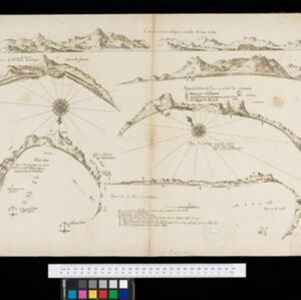
De Straat Sunda in de Oost-Indische Zee tussen de eylanden Sumatra en Iava
1728
Indonesia
Chart of the Sunda Strait, focusing on bays and islands, and showing bathymetry (sea depth), anchor points, shoals and reefs, landmarks, and a rhumbline network, all to aid navigation. Includes an inset map of the bay of the city of Banten on Java.

Chart... Shewing the Connection and respective distances by Sea, between the principal harbours and Settlements in the East Indies
1794
Thailand, Myanmar, Malaysia, Indonesia
Maritime routes had to be adjusted in response to the changing monsoon seasons, as is seen on this late 18th century map of the Indian Ocean. Drawings of the heads of children blowing—called ‘wind-heads’—are used to indicate wind direction.

A chart of north-west coast of Borneo: from Balambangan to Borneo proper
1794
Malaysia
Nautical charts, like this late 18th century example of the north-west coast of Borneo, were designed to help ships navigate. The numbers marked along the coastline and sea routes indicate the depth of the sea (bathymetry).

A new chart of the north coast of Java: wherein are described the roads of Bantam and Batavia
1794
Indonesia
Map of the Batavia (Jakarta) and Bantam (Bantem) roadsteads (a body of water sheltered from tides/currents, for ships to anchor). Shoals, reefs and bathymetry (sea depth) are marked, with explanatory notes and a rhumbline network to aid navigation.

A new chart of the straits of Sunda: From the manuscript of the Dutch East India Company
1794
Indonesia
Navigation chart of the Sunda Strait, showing bathymetry (sea depth), shoals and reefs, landmarks, and a rhumbline network. Notes record good anchorages, sources of water and supplies etc. Inset map of the Zutphen Islands off the coast of Sumatra.


Reduzirte Karte vom Sunda- oder Borneo-Meere
1835
Malaysia, Indonesia
A navigation map of the Java Sea and Sunda Islands, with bathymetry (sea depth), maritime routes, shoals and reefs, and elevations (side views of terrestrial landmarks). Inset maps feature the bay at Batavia and the straits between the Sunda Islands.


