
Search Results


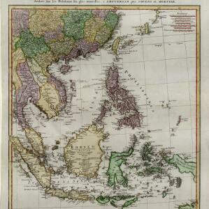
East Indies
1769
Brunei, Cambodia, East Timor, Indonesia, Laos, Malaysia, Myanmar, Philippines, Singapore, Southeast Asia, Thailand, Vietnam
Longitude is indicated in two different ways on this mid-18th century map: along the top border, it is shown in degrees (number of degrees east of London); more unusually, along the bottom border, it is shown in time (number of hours east of London).

A chart of the seas between the Straits of Banca and Po. Timon: with the eastern part of the Straits of Malacca
1767
Indonesia, Malaysia
This mid-18th century maritime map charts the seas between Peninsula Malaysia and Sumatra, including Singapore—named ‘Po. Panjang’—with the old and new Straits of Singapore marked. The numbers indicate sea depth (bathymetry).

Isles de la Sonde
1767
Brunei, Indonesia, Malaysia, Singapore
Three of the larger Sunda Islands—Sumatra, Java and Borneo—are shown on this mid-18th century map, along with a few of the smaller islands such as Bali, Lombok and Sumbawa. Celebes (Sulawesi) and some of the other smaller islands are not included.


Carte des Isles de Java, Sumatra, Borneo &c. Les détroits de la Sonde, Malaca et Banca, Golfe de Siam &c.
1764
Brunei, Cambodia, Indonesia, Malaysia, Singapore, Thailand, Vietnam, Philippines
This map shows the islands of Java, Sumatra and Borneo, the straits of Sunda, Malacca and Bangka, and the Gulf of Siam. The points of the compass can be seen radiating out from a central compass rose.

Karte von dem eylande Sumatra nach den tagebüchern der schiffer
1764
Malaysia, Indonesia, Singapore
The title of this mid-18th century map of Sumatra and the Malay Peninsula claims that it was based on the diaries of sailors. Interestingly, the title is repeated in both German and French, as are the names of some of the locations marked on the map.

Carte d'une partie de la Chine, les Isles Philippines, de la Sonde, Moluques, de Papoesi, &c.
1758
Brunei, Cambodia, East Timor, Indonesia, Laos, Malaysia, Myanmar, Philippines, Singapore, Southeast Asia, Thailand, Vietnam
There are some labels on this mid-18th century map of Southeast Asia describing the local populations, including the Ke-moy, a ‘Nation sauvage [savage people]’ living in the mountains on the border of Cochinchine (Vietnam) and Camboja (Cambodia).
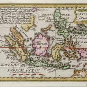
East India islands
1758
Brunei, East Timor, Indonesia, Malaysia, Philippines, Singapore
Text on this mid-18th century map notes the dimensions of the islands of maritime Southeast Asia, in length, breadth and square miles (e.g. ‘Java 580 long, 105 broad, & 38,250 sq.’). It also states that the Dutch are the main traders in the region.

Carte réduite des détroits de Malaca, Sincapour, et du Gouverneur
1755
Malaysia, Singapore, Indonesia
Maps like this aided navigation through the islands, shoals and reefs of Singapore and the Malacca Strait. Three routes around Singapore are shown, numbers on the sea indicate water depth, and the profile views of mountains were used as landmarks.

Plan de la ville et forteresse de Malaca: pour servir à l'histoire generale des voyages
1750
Malaysia
This mid-18th century plan of the city of Malaca (Malacca/Melaka) focuses on the military fort (‘A Famosa [The Famous]’), but also includes two churches, a mosque and a Chinese temple. Two markets are also marked, as is the entrance to the port.
- Indonesia285
- Malaysia214
- Singapore202
- Thailand188
- Cambodia183
- Vietnam180
- Myanmar176
- Brunei172
- Laos170
- Philippines165
- Southeast Asia152
- East Timor146
- more Simple Location »


