
Search Results
1637 Results found

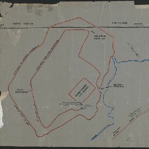
[Outline map of the capital Co-loa, North Vietnam]
1900
Vietnam
This map of the fortified settlement of Cổ Loa (near Hanoi, northern Vietnam) shows the royal city, battlements and gates, a temple and a well. Artefacts dating to the Bronze Age have been found on this early site of Vietnamese civilization.

Sketch showing positions of 1st Brigade, 2nd Division, 8th Corps, in operations against Manila
1900
Philippines
Created by the U.S. Army, this map of a small area south of Manila records Spanish and American trenches and troop and gun locations on the last day of the Spanish–American War (13 August 1898). Ground conditions (swamps, jungle, fields) are noted.


[Various Indonesian islands]
c.1900
Malaysia, Brunei, Indonesia, Singapore
Seven locations in the Dutch East Indies on one sheet: the islands of Borneo, Sumatra, Celebes (Sulawesi), Ambon and Banda, the city of Padang and its region on the west coast of Sumatra, and the tip of the Minahasa Peninsula (northern Celebes).
- Filter from 1478 to 1900
- Indonesia1,345
- Malaysia802
- Thailand724
- Myanmar715
- Singapore705
- Vietnam670
- Cambodia646
- Brunei624
- Philippines617
- Laos597
- East Timor559
- Southeast Asia523
- more Simple Location »
- Java846
- Sumatra843
- Borneo693
- Malay Peninsula585
- Sulawesi553
- Celebes475
- Dutch East Indies468
- Siam389
- Maluku Islands374
- Western New Guinea360
- Sunda Islands279
- Malacca264
- more Detailed Location »
- Port211
- Pier84
- Railway Station58
- River1,179
- Road420
- Path219
- Railway/Tramway181
- Postal Route98
- Canal92
- Bridge83
- Telegraph/Telephone63
- Legend622
- Cartouche423
- Illustration357
- Inset Map330
- Elevation153
- Coat of Arms120


