
Search Results
1637 Results found


Kaart der hoofdplaats Batavia omstreeks het jaar 1740
1898
Indonesia
A mid-18th century map of the important port of Batavia (Jakarta), with military forts, a pier, hospitals, churches, and residential streets. However, the city is also surrounded by fields and plantations, for producing crops and grazing animals.
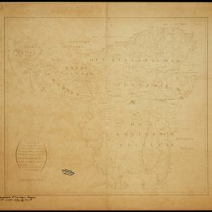
Caart eeniger ryken gelegen op het eyland Groot Java bestaande in het Koningryk Jaccatra de regentschappen Tjanjoer, Bandong, Timbanganten en Batoelejan als mede een gedeelte van Parrakkanmoentjang en Crawang
1898
Indonesia
A hand-drawn late 19th century map of western Java, divided into regencies. The map is orientated with south at the top so that Batavia, on the northern coast of Java, is at the bottom of the map.


Overzichtskaart van Groot-Atjeh en aangrenzende kuststaten
1898
Indonesia
Map of Groot-Atjeh (Aceh, Sumatra), focusing on the area around the capital Kota Radja (Banda Aceh) and along the coasts. There is a list of telephone connections in the area, and an inset map of the region divided into administrative districts.

De stad Batavia met derzelver omstreken: Geteekend in 1826
1898
Indonesia
The city of Batavia (Jakarta) with its port and castle is to the north (right side of the map). Koningsplein (Merdeka Square), a large area of rice paddies, graveyards and villages can be seen to the south (left). Copied from a c.1826 map.


Situatieplan van Batavia desselfs stranden en ommelanden
1898
Indonesia
Plan of the city of Batavia (Jakarta), its suburbs and surrounding areas, focussing on the river and canal system. This is a copy of an original c.1790 map. The pier has been pencilled in, as it was not built when the original map was produced.

Westkust Celebes: Vaarwaters benoorden Makasser: Blad I
1898
Indonesia
Navigation map of the west coast of Celebes (Sulawesi), north of Makassar. Bathymetry (sea depth), lighthouses, shoals and other obstructions are marked, with trees and hills as landmarks, and elevations (side views of hills) to aid navigation.

Westkust Celebes: Vaarwaters benoorden Makasser: Blad III
1898
Indonesia
Navigation map of the west coast of Celebes (Sulawesi), north of Makassar. Bathymetry (sea depth), shoals and other obstructions are marked, with hills and settlements as landmarks, and elevations (side views of hills) to aid navigation.

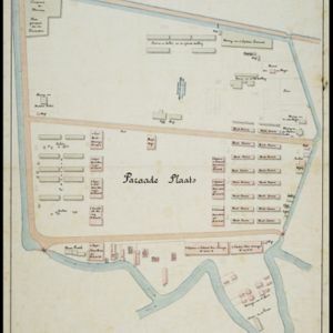
Plattegrond van de stad en casteel Batavia, met de daarnaast gelegene situatie
1898
Indonesia
Plan of the port city of Batavia (Jakarta) with the pier (and North) at the bottom. There is a legend, and an illustrated cartouche featuring a female figure holding an oar and a shield decorated with the ‘VOC’ logo of the Dutch East India Company.
- Filter from 1478 to 1900
- Indonesia1,345
- Malaysia802
- Thailand724
- Myanmar715
- Singapore705
- Vietnam670
- Cambodia646
- Brunei624
- Philippines617
- Laos597
- East Timor559
- Southeast Asia523
- more Simple Location »
- Java846
- Sumatra843
- Borneo693
- Malay Peninsula585
- Sulawesi553
- Celebes475
- Dutch East Indies468
- Siam389
- Maluku Islands374
- Western New Guinea360
- Sunda Islands279
- Malacca264
- more Detailed Location »
- Port211
- Pier84
- Railway Station58
- River1,179
- Road420
- Path219
- Railway/Tramway181
- Postal Route98
- Canal92
- Bridge83
- Telegraph/Telephone63
- Legend622
- Cartouche423
- Illustration357
- Inset Map330
- Elevation153
- Coat of Arms120


